Weather Alert in New York
High Wind Watch issued March 14 at 1:29PM EDT until March 16 at 8:00PM EDT by NWS Buffalo NY
AREAS AFFECTED: Chautauqua; Southern Erie
DESCRIPTION: * WHAT...South to southeast winds 20 to 35 mph with gusts up to 60 mph possible through Sunday night. Winds become southwest Monday with a few gusts up to 50 mph. * WHERE...Chautauqua and Southern Erie Counties. Strongest gusts Sunday night expected along the northwest downslope region of the Chautauqua Ridge and to the Lake Erie shoreline. Strongest wind gusts Monday will be regionwide. * WHEN...From Sunday afternoon through Monday evening. Strongest gusts expected Sunday night. * IMPACTS...Strong winds may blow down trees and power lines. Scattered power outages are possible. Travel may be difficult, especially for high profile vehicles.
INSTRUCTION: Monitor the latest forecasts and warnings for updates. Secure or shelter objects in a safe location prior to the onset of the strong winds.
Want more detail? Get the Complete 7 Day and Night Detailed Forecast!
Current U.S. National Radar--Current
The Current National Weather Radar is shown below with a UTC Time (subtract 5 hours from UTC to get Eastern Time).

National Weather Forecast--Current
The Current National Weather Forecast and National Weather Map are shown below.

National Weather Forecast for Tomorrow
Tomorrow National Weather Forecast and Tomorrow National Weather Map are show below.

North America Water Vapor (Moisture)
This map shows recent moisture content over North America. Bright and colored areas show high moisture (ie, clouds); brown indicates very little moisture present; black indicates no moisture.

Weather Topic: What is Hail?
Home - Education - Precipitation - Hail
 Next Topic: Hole Punch Clouds
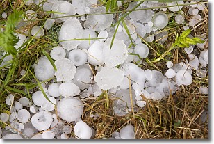
Hail is a form of precipitation which is recognized by large solid balls or
clumps of ice. Hail is created by thunderstorm clouds with strong updrafts of wind.
As the hailstones remain in the updraft, ice is deposited onto them until their
weight becomes heavy enough for them to fall to the earth's surface.
Hail storms can cause significant damage to crops, aircrafts, and man-made structures,
despite the fact that the duration is usually less than ten minutes.
Next Topic: Hole Punch Clouds
Weather Topic: What are Mammatus Clouds?
Home - Education - Cloud Types - Mammatus Clouds
 Next Topic: Nimbostratus Clouds
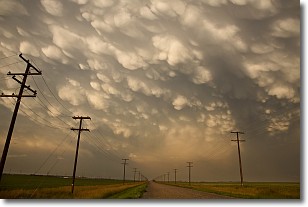
A mammatus cloud is a cloud with a unique feature which resembles
a web of pouches hanging along the base of the cloud.
In the United States, mammatus clouds tend to form in the warmer months, commonly
in the Midwest and eastern regions.
While they usually form at the bottom of a cumulonimbis cloud, they can also form
under altostratus, altocumulus, stratocumulus, and cirrus clouds. Mammatus clouds
warn that severe weather is close.
Next Topic: Nimbostratus Clouds
Current conditions powered by WeatherAPI.com


