Weather Alert in Minnesota
Blizzard Warning issued March 14 at 1:08PM CDT until March 16 at 4:00AM CDT by NWS Twin Cities/Chanhassen MN
AREAS AFFECTED: Douglas; Todd; Morrison; Mille Lacs; Kanabec
DESCRIPTION: ...HISTORIC MARCH WINTER STORM ON TRACK TO BRING EXTREME SNOW ACCUMULATIONS AND STRONG WINDS... ...A WINTRY MIX OF RAIN, FREEZING RAIN, AND SLEET LATE TONIGHT ACROSS SOUTH CENTRAL MINNESOTA... ...TRAVEL MAY BECOME IMPOSSIBLE LATE TONIGHT AND SUNDAY... .A historic March winter storm will move across the Upper Midwest starting this evening and lasting into Sunday night. Heavy snow with a broad area of 12 to 18 inches expected across central Minnesota and western Wisconsin. A narrow swath within the broader area may approach 2 feet in parts of far east central Minnesota and west central Wisconsin. Rates of 2 to 2.5 inches per hour are likely late tonight into Sunday morning. A wintry mix of rain, freezing rain, and sleet is expected to work north into I-90 corridor of southern Minnesota tonight. A half inch of sleet and a tenth of an inch of ice are expected along the I-90 corridor. The wintry mix will turn to all snow Sunday morning. Winds will increase on Sunday. Even though the snow will be tapering off gradually throughout Sunday, northwest winds will increase to 35 to 45 mph. Some gusts of 50 to 55 mph are possible across the Minnesota River Valley. The combination of falling snow, blowing snow, and gusty winds will reduce visibility and create blizzard conditions late tonight through Sunday evening across central and southern Minnesota and western Wisconsin. Travel is expected to become very difficult or impossible late tonight through Sunday evening. In addition, the amount of water in the snowpack will make it very heavy, leading to the potential for infrastructure damage and a health hazard for those shoveling. * WHAT...Blizzard conditions expected. Total snow accumulations between 6 and 12 inches. Winds gusting as high as 45 mph Sunday afternoon and evening. * WHERE...Morrison, Todd, Kanabec, Mille Lacs, and Douglas Counties. * WHEN...From 10 PM this evening to 4 AM CDT Monday. * IMPACTS...Travel could be very difficult. Widespread blowing snow could significantly reduce visibility. Gusty winds could bring down tree branches.
INSTRUCTION: Travel should be restricted to emergencies only. If you must travel, have a winter survival kit with you. If you get stranded, stay with your vehicle. Call 5 1 1 or visit 511mn.org for road conditions.
Want more detail? Get the Complete 7 Day and Night Detailed Forecast!
Current U.S. National Radar--Current
The Current National Weather Radar is shown below with a UTC Time (subtract 5 hours from UTC to get Eastern Time).

National Weather Forecast--Current
The Current National Weather Forecast and National Weather Map are shown below.

National Weather Forecast for Tomorrow
Tomorrow National Weather Forecast and Tomorrow National Weather Map are show below.

North America Water Vapor (Moisture)
This map shows recent moisture content over North America. Bright and colored areas show high moisture (ie, clouds); brown indicates very little moisture present; black indicates no moisture.

Weather Topic: What are Fractus Clouds?
Home - Education - Cloud Types - Fractus Clouds
 Next Topic: Freezing Rain
A fractus cloud (scud) is a fragmented, tattered cloud which has
likely been sheared off of another cloud. They are accessory clouds, meaning they
develop from parent clouds, and are named in a way which describes the original
cloud which contained them.
Fractus clouds which have originated from cumulus clouds are referred to as
cumulus fractus, while fractus clouds which have originated from stratus clouds
are referred to as stratus fractus. Under certain conditions a fractus cloud might
merge with another cloud, or develop into a cumulus cloud, but usually a
fractus cloud seen by itself will dissipate rapidly.
They are often observed on the leading and trailing edges of storm clouds,
and are a display of wind activity.
Next Topic: Freezing Rain
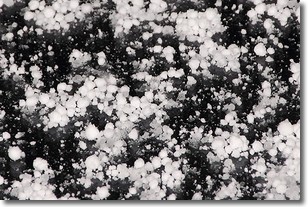
Weather Topic: What is Graupel?
Home - Education - Precipitation - Graupel
 Next Topic: Hail
Graupel is a form of precipitation that is created by atmospheric conditions
which cause supercooled water droplets to contact snow crystals and freeze to
their surface.
Sometimes known as soft hail or snow pellets, graupel is delicate and easily
destroyed by touch. Whereas hail usually falls during severe weather, graupel
doesn't require such conditions to form, and can form in mild precipitation
similar to situations which produce snowfall.
Next Topic: Hail
Current conditions powered by WeatherAPI.com


