Weather Alert in Minnesota
Blizzard Warning issued March 14 at 1:08PM CDT until March 16 at 4:00AM CDT by NWS Twin Cities/Chanhassen MN
AREAS AFFECTED: Stearns; Benton; Sherburne; Isanti; Chisago; Wright; Hennepin; Anoka; Ramsey; Washington; Carver; Scott; Dakota; Goodhue
DESCRIPTION: ...HISTORIC MARCH WINTER STORM ON TRACK TO BRING EXTREME SNOW ACCUMULATIONS AND STRONG WINDS... ...A WINTRY MIX OF RAIN, FREEZING RAIN, AND SLEET LATE TONIGHT ACROSS SOUTH CENTRAL MINNESOTA... ...TRAVEL MAY BECOME IMPOSSIBLE LATE TONIGHT AND SUNDAY... .A historic March winter storm will move across the Upper Midwest starting this evening and lasting into Sunday night. Heavy snow with a broad area of 12 to 18 inches expected across central Minnesota and western Wisconsin. A narrow swath within the broader area may approach 2 feet in parts of far east central Minnesota and west central Wisconsin. Rates of 2 to 2.5 inches per hour are likely late tonight into Sunday morning. A wintry mix of rain, freezing rain, and sleet is expected to work north into I-90 corridor of southern Minnesota tonight. A half inch of sleet and a tenth of an inch of ice are expected along the I-90 corridor. The wintry mix will turn to all snow Sunday morning. Winds will increase on Sunday. Even though the snow will be tapering off gradually throughout Sunday, northwest winds will increase to 35 to 45 mph. Some gusts of 50 to 55 mph are possible across the Minnesota River Valley. The combination of falling snow, blowing snow, and gusty winds will reduce visibility and create blizzard conditions late tonight through Sunday evening across central and southern Minnesota and western Wisconsin. Travel is expected to become very difficult or impossible late tonight through Sunday evening. In addition, the amount of water in the snowpack will make it very heavy, leading to the potential for infrastructure damage and a health hazard for those shoveling. * WHAT...Blizzard conditions expected. Total snow accumulations between 12 and 18 inches. Winds gusting as high as 45 mph Sunday afternoon and evening. * WHERE...Benton, Sherburne, Stearns, Wright, Anoka, Carver, Chisago, Dakota, Hennepin, Isanti, Ramsey, Scott, Washington, and Goodhue Counties. * WHEN...From 10 PM this evening to 4 AM CDT Monday. * IMPACTS...Travel could be very difficult to impossible. Widespread blowing snow could significantly reduce visibility. Gusty winds could bring down tree branches.
INSTRUCTION: Travel should be restricted to emergencies only. If you must travel, have a winter survival kit with you. If you get stranded, stay with your vehicle. Call 5 1 1 or visit 511mn.org for road conditions.
Want more detail? Get the Complete 7 Day and Night Detailed Forecast!
Current U.S. National Radar--Current
The Current National Weather Radar is shown below with a UTC Time (subtract 5 hours from UTC to get Eastern Time).

National Weather Forecast--Current
The Current National Weather Forecast and National Weather Map are shown below.

National Weather Forecast for Tomorrow
Tomorrow National Weather Forecast and Tomorrow National Weather Map are show below.

North America Water Vapor (Moisture)
This map shows recent moisture content over North America. Bright and colored areas show high moisture (ie, clouds); brown indicates very little moisture present; black indicates no moisture.

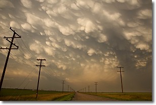
Weather Topic: What are Mammatus Clouds?
Home - Education - Cloud Types - Mammatus Clouds
 Next Topic: Nimbostratus Clouds
A mammatus cloud is a cloud with a unique feature which resembles
a web of pouches hanging along the base of the cloud.
In the United States, mammatus clouds tend to form in the warmer months, commonly
in the Midwest and eastern regions.
While they usually form at the bottom of a cumulonimbis cloud, they can also form
under altostratus, altocumulus, stratocumulus, and cirrus clouds. Mammatus clouds
warn that severe weather is close.
Next Topic: Nimbostratus Clouds
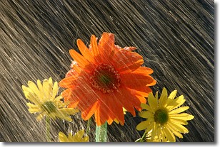
Weather Topic: What is Precipitation?
Home - Education - Precipitation - Precipitation
 Next Topic: Rain
Precipitation can refer to many different forms of water that
may fall from clouds. Precipitation occurs after a cloud has become saturated to
the point where its water particles are more dense than the air below the cloud.
In most cases, precipitation will reach the ground, but it is not uncommon for
precipitation to evaporate before it reaches the earth's surface.
When precipitation evaporates before it contacts the ground it is called Virga.
Graupel, hail, sleet, rain, drizzle, and snow are forms of precipitation, but fog
and mist are not considered precipitation because the water vapor which
constitutes them isn't dense enough to fall to the ground.
Next Topic: Rain
Current conditions powered by WeatherAPI.com


