Weather Alert in Colorado
High Wind Warning issued March 14 at 2:27PM MDT until March 15 at 3:00PM MDT by NWS Denver CO
AREAS AFFECTED: North Douglas County Below 6000 Feet/Denver/West Adams and Arapahoe Counties/East Broomfield County; Elbert/Central and East Douglas Counties Above 6000 Feet; Northeast Weld County; Central and South Weld County; Morgan County; Central and East Adams and Arapahoe Counties; North and Northeast Elbert County Below 6000 Feet/North Lincoln County; Southeast Elbert County Below 6000 Feet/South Lincoln County; Logan County; Washington County; Sedgwick County; Phillips County
DESCRIPTION: * WHAT...Northwest winds 25 to 35 mph with gusts up to 65 mph expected. * WHERE...Portions of east central and northeast Colorado, including Greeley, the Denver metro, Palmer Divide, and the eastern plains. * WHEN...From 10 PM this evening to 3 PM MDT Sunday. * IMPACTS...Gusty winds will blow around unsecured objects and a few power outages may result. Blowing dust could reduce visibility to less than a mile in places.
INSTRUCTION: People are urged to secure loose objects that could be blown around or damaged by the wind. Winds this strong can make driving difficult, especially for high profile vehicles. Use extra caution.
Want more detail? Get the Complete 7 Day and Night Detailed Forecast!
Current U.S. National Radar--Current
The Current National Weather Radar is shown below with a UTC Time (subtract 5 hours from UTC to get Eastern Time).

National Weather Forecast--Current
The Current National Weather Forecast and National Weather Map are shown below.

National Weather Forecast for Tomorrow
Tomorrow National Weather Forecast and Tomorrow National Weather Map are show below.

North America Water Vapor (Moisture)
This map shows recent moisture content over North America. Bright and colored areas show high moisture (ie, clouds); brown indicates very little moisture present; black indicates no moisture.

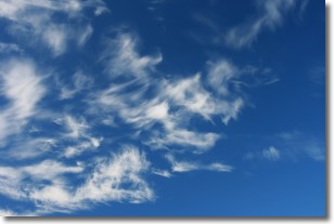
Weather Topic: What are Cirrostratus Clouds?
Home - Education - Cloud Types - Cirrostratus Clouds
 Next Topic: Cirrus Clouds
Cirrostratus clouds are high, thin clouds that form above
20,000 feet and are made mostly of ice crystals. They sometimes look like giant
feathers, horse tails, or curls of hair in the sky.
These clouds are pushed by the jet stream and can move at high speeds reaching
100 mph.
What do they indicate?
They indicate that a precipitation is likely within 24 hours.
Next Topic: Cirrus Clouds
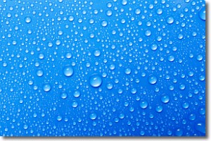
Weather Topic: What is Condensation?
Home - Education - Precipitation - Condensation
 Next Topic: Contrails
Condensation is the process which creates clouds, and therefore
it is a crucial process in the water cycle.
Condensation is the change of matter from a state of gas into a state of liquid,
and it happens because water molecules release heat into the atmosphere and
become organized into a more closely packed structure, what we might see as
water droplets.
Water is always present in the air around us as a vapor, but it's too small for
us to see. When water undergoes the process of condensation it becomes organized
into visible water droplets. You've probably seen condensation happen before on the
surface of a cold drink!
Next Topic: Contrails
Current conditions powered by WeatherAPI.com


