Weather Alert in Arizona
Flood Watch issued August 23 at 1:18AM MST until August 25 at 8:00PM MST by NWS Flagstaff AZ
AREAS AFFECTED: Kaibab Plateau; Marble and Glen Canyons; Grand Canyon Country
DESCRIPTION: * WHAT...Flash flooding caused by excessive rainfall is possible. * WHERE...A portion of north central Arizona, including the following areas, Grand Canyon Country, Kaibab Plateau and Marble and Glen Canyons, including the Dragon Bravo and White Sage fire burn scars. * WHEN...From 11 AM MST /noon MDT/ this morning through Monday evening. * IMPACTS...Flash flooding will be possible in creeks, normally dry washes, swimming holes, and over recently burned areas. Raging killer currents will be possible in side canyons and narrow slot canyons. Low-water crossings may be flooded. * ADDITIONAL DETAILS... - Numerous showers and thunderstorms are expected over the next few days, capable of producing heavy rainfall over a short period of time. - Additional information is available at weather.gov/flagstaff.
INSTRUCTION: Have a way to receive Flash Flood Warnings and be prepared to take action should warnings be issued. Consider changing your plans if you were going to hike, boat, or paddleboard to a slot canyon or normally dry wash. If you do still decide to recreate, check in at a nearby visitor center or ranger station. People planning river trips on the Colorado River between Glen Canyon Dam and the west end of Grand Canyon National Park should be aware of the possibility of Flash Flooding from the side canyons and plan accordingly. The White Sage and Dragon Bravo fire burn scars will be especially susceptible to Flash Flooding. Use extreme caution if working in or around these areas.
Want more detail? Get the Complete 7 Day and Night Detailed Forecast!
Current U.S. National Radar--Current
The Current National Weather Radar is shown below with a UTC Time (subtract 5 hours from UTC to get Eastern Time).

National Weather Forecast--Current
The Current National Weather Forecast and National Weather Map are shown below.

National Weather Forecast for Tomorrow
Tomorrow National Weather Forecast and Tomorrow National Weather Map are show below.

North America Water Vapor (Moisture)
This map shows recent moisture content over North America. Bright and colored areas show high moisture (ie, clouds); brown indicates very little moisture present; black indicates no moisture.

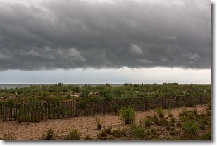
Weather Topic: What are Shelf Clouds?
Home - Education - Cloud Types - Shelf Clouds
 Next Topic: Sleet
A shelf cloud is similar to a wall cloud, but forms at the front
of a storm cloud, instead of at the rear, where wall clouds form.
A shelf cloud is caused by a series of events set into motion by the advancing
storm; first, cool air settles along the ground where precipitation has just fallen.
As the cool air is brought in, the warmer air is displaced, and rises above it,
because it is less dense. When the warmer air reaches the bottom of the storm cloud,
it begins to cool again, and the resulting condensation is a visible shelf cloud.
Next Topic: Sleet
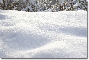
Weather Topic: What is Snow?
Home - Education - Precipitation - Snow
 Next Topic: Stratocumulus Clouds
Snow is precipitation taking the form of ice crystals. Each ice crystal, or snowflake,
has unique characteristics, but all of them grow in a hexagonal structure.
Snowfall can last for sustained periods of time and result in significant buildup
of snow on the ground.
On the earth's surface, snow starts out light and powdery, but as it begins to melt
it tends to become more granular, producing small bits of ice which have the consistency of
sand. After several cycles of melting and freezing, snow can become very dense
and ice-like, commonly known as snow pack.
Next Topic: Stratocumulus Clouds
Current conditions powered by WeatherAPI.com


