Weather Alert in Minnesota
Blizzard Warning issued March 15 at 10:25AM CDT until March 16 at 7:00AM CDT by NWS La Crosse WI
AREAS AFFECTED: Wabasha; Dodge; Olmsted; Winona; Mower; Fillmore; Houston; Taylor; Clark; Buffalo; Trempealeau; Jackson
DESCRIPTION: ...BLIZZARD CONDITIONS WITH ADDITIONAL SNOW MOVING IN THIS AFTERNOON... .The first round of this winter storm is beginning to exit the area late this morning which will leave a brief lull across the area for the late morning and early afternoon. During this period, winds will begin to increase with wind gusts of 40 to 55 mph by the early evening. This will result in blizzard conditions where a Blizzard Warning is in effect. Dangerous travel conditions are expected during this period, particularly north of Interstate 90 where snowfall totals of 12 to 24 inches will see significant drifting with the increasing winds. A secondary round of accumulating snow will move into the region late this afternoon and into the morning hours on Monday with highest additional totals favored in west-central and southwest Wisconsin with snow exiting the region by noon on Monday. * WHAT...Blizzard conditions. Additional snow accumulations between 4 and 10 inches. Winds gusting as high as 55 mph. * WHERE...Portions of southeast Minnesota and central, north central, and west central Wisconsin. * WHEN...Until 7 AM CDT Monday. * IMPACTS...Travel could be very difficult. Widespread blowing snow could significantly reduce visibility. The hazardous conditions could impact the Monday morning commute. Strong winds could cause tree damage.
INSTRUCTION: Travel should be restricted to emergencies only. If you must travel, have a winter survival kit with you. If you get stranded, stay with your vehicle. In Minnesota, visit 511mn.org for road conditions. In Wisconsin, visit 511wi.gov for road conditions.
Want more detail? Get the Complete 7 Day and Night Detailed Forecast!
Current U.S. National Radar--Current
The Current National Weather Radar is shown below with a UTC Time (subtract 5 hours from UTC to get Eastern Time).

National Weather Forecast--Current
The Current National Weather Forecast and National Weather Map are shown below.

National Weather Forecast for Tomorrow
Tomorrow National Weather Forecast and Tomorrow National Weather Map are show below.

North America Water Vapor (Moisture)
This map shows recent moisture content over North America. Bright and colored areas show high moisture (ie, clouds); brown indicates very little moisture present; black indicates no moisture.

Weather Topic: What is Condensation?
Home - Education - Precipitation - Condensation
 Next Topic: Contrails
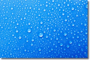
Condensation is the process which creates clouds, and therefore
it is a crucial process in the water cycle.
Condensation is the change of matter from a state of gas into a state of liquid,
and it happens because water molecules release heat into the atmosphere and
become organized into a more closely packed structure, what we might see as
water droplets.
Water is always present in the air around us as a vapor, but it's too small for
us to see. When water undergoes the process of condensation it becomes organized
into visible water droplets. You've probably seen condensation happen before on the
surface of a cold drink!
Next Topic: Contrails
Weather Topic: What are Cumulonimbus Clouds?
Home - Education - Cloud Types - Cumulonimbus Clouds
 Next Topic: Cumulus Clouds
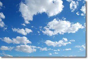
The final form taken by a growing cumulus cloud is the
cumulonimbus cloud, which is very tall and dense.
The tower of a cumulonimbus cloud can soar 23 km into the atmosphere, although
most commonly they stop growing at an altitude of 6 km.
Even small cumulonimbus clouds appear very large in comparison to other cloud types.
They can signal the approach of stormy weather, such as thunderstorms or blizzards.
Next Topic: Cumulus Clouds
Current conditions powered by WeatherAPI.com


