Weather Alert in Louisiana
Fire Weather Watch issued March 14 at 10:37PM CDT until March 16 at 8:00PM CDT by NWS Lake Charles LA
AREAS AFFECTED: Vernon; Rapides; Avoyelles; Beauregard; Allen; Evangeline; St. Landry; Lafayette; Upper St. Martin; Lower St. Martin; West Cameron; East Cameron; Northern Calcasieu; Northern Jefferson Davis; Northern Acadia; Upper Vermilion; Upper Iberia; Upper St. Mary; Southern Calcasieu; Southern Jefferson Davis; Southern Acadia; Lower Vermilion; Lower Iberia; Lower St. Mary; Tyler; Hardin; Northern Jasper; Northern Newton; Southern Jasper; Southern Newton; Upper Jefferson; Northern Orange; Lower Jefferson; Southern Orange
DESCRIPTION: ...FIRE WEATHER WATCH AREA WIDE... .Windy and dry conditions behind a cold front may produce red flag conditons across much of the area Monday. The National Weather Service in Lake Charles has issued a Fire Weather Watch for strong winds and low humidity, which is in effect from Monday morning through Monday evening. * AFFECTED AREA...Fire Weather Zone 027 Vernon, Fire Weather Zone 028 Rapides, Fire Weather Zone 029 Avoyelles, Fire Weather Zone 030 Beauregard, Fire Weather Zone 031 Allen, Fire Weather Zone 032 Evangeline, Fire Weather Zone 033 St. Landry, Fire Weather Zone 044 Lafayette, Fire Weather Zone 045 Upper St. Martin, Fire Weather Zone 055 Lower St. Martin, Fire Weather Zone 073 West Cameron, Fire Weather Zone 074 East Cameron, Fire Weather Zone 141 Northern Calcasieu, Fire Weather Zone 142 Northern Jefferson Davis, Fire Weather Zone 143 Northern Acadia, Fire Weather Zone 152 Upper Vermilion, Fire Weather Zone 153 Upper Iberia, Fire Weather Zone 154 Upper St. Mary, Fire Weather Zone 180 Tyler, Fire Weather Zone 201 Hardin, Fire Weather Zone 241 Southern Calcasieu, Fire Weather Zone 242 Southern Jefferson Davis, Fire Weather Zone 243 Southern Acadia, Fire Weather Zone 252 Lower Vermilion, Fire Weather Zone 253 Lower Iberia, Fire Weather Zone 254 Lower St. Mary, Fire Weather Zone 259 Northern Jasper, Fire Weather Zone 260 Northern Newton, Fire Weather Zone 261 Southern Jasper, Fire Weather Zone 262 Southern Newton, Fire Weather Zone 515 Upper Jefferson, Fire Weather Zone 516 Northern Orange, Fire Weather Zone 615 Lower Jefferson and Fire Weather Zone 616 Southern Orange. * TIMING...From Monday morning through Monday evening. * WINDS...North 10 to 20 mph with gusts up to 30 mph. * RELATIVE HUMIDITY...As low as 20 percent. * TEMPERATURES...Up to 55. * IMPACTS...Any fire that develops will catch and spread quickly. Outdoor burning is not recommended. Obey all local burn bans.
INSTRUCTION: A Fire Weather Watch means that critical fire weather conditions are forecast to occur. Listen for later forecasts and possible Red Flag Warnings.
Want more detail? Get the Complete 7 Day and Night Detailed Forecast!
Current U.S. National Radar--Current
The Current National Weather Radar is shown below with a UTC Time (subtract 5 hours from UTC to get Eastern Time).

National Weather Forecast--Current
The Current National Weather Forecast and National Weather Map are shown below.

National Weather Forecast for Tomorrow
Tomorrow National Weather Forecast and Tomorrow National Weather Map are show below.

North America Water Vapor (Moisture)
This map shows recent moisture content over North America. Bright and colored areas show high moisture (ie, clouds); brown indicates very little moisture present; black indicates no moisture.

Weather Topic: What is Freezing Rain?
Home - Education - Precipitation - Freezing Rain
 Next Topic: Graupel
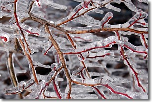
Freezing rain is a condition where precipitation which has fallen in the form of
water droplets reaches temperatures which are below freezing and freezes upon
coming into contact
with surface objects. The result of this precipitation is a glaze of ice which
can be damaging to plants and man-made structures. A severe onset of freezing
rain which results in a very thick glaze of ice is known as an ice storm.
Next Topic: Graupel
Weather Topic: What is Hail?
Home - Education - Precipitation - Hail
 Next Topic: Hole Punch Clouds
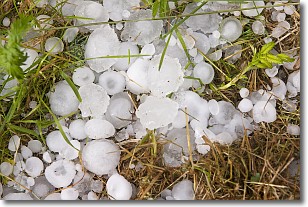
Hail is a form of precipitation which is recognized by large solid balls or
clumps of ice. Hail is created by thunderstorm clouds with strong updrafts of wind.
As the hailstones remain in the updraft, ice is deposited onto them until their
weight becomes heavy enough for them to fall to the earth's surface.
Hail storms can cause significant damage to crops, aircrafts, and man-made structures,
despite the fact that the duration is usually less than ten minutes.
Next Topic: Hole Punch Clouds
Current conditions powered by WeatherAPI.com


