Weather Alert in Montana
Winter Weather Advisory issued March 14 at 11:03AM MDT until March 15 at 12:00AM MDT by NWS Missoula MT
AREAS AFFECTED: Butte/Blackfoot Region
DESCRIPTION: * WHAT...Snow. There is a likelihood of developing or ongoing moderate winter weather impacts. Additional snow accumulations between 1 and 5 inches. Winds gusting as high as 55 mph. * WHERE...Georgetown Lake, Highway 12 Garrison to Elliston, Butte, Homestake Pass, and MacDonald Pass. * WHEN...Until midnight MDT tonight. * IMPACTS...For MODERATE winter weather impacts, expect disruptions to normal activities. Hazardous traveling conditions. Use extra caution while driving. Closures and disruptions to infrastructure may occur. Wet, heavy snow, and winds could cause tree damage. * ADDITIONAL DETAILS...Intense snow squalls are expected this afternoon through evening causing periods of very heavy snow, gusty winds, and icy conditions.
INSTRUCTION: Slow down and use caution while traveling. The latest road conditions for the state you are calling from can be obtained by calling 5 1 1.
Want more detail? Get the Complete 7 Day and Night Detailed Forecast!
Current U.S. National Radar--Current
The Current National Weather Radar is shown below with a UTC Time (subtract 5 hours from UTC to get Eastern Time).

National Weather Forecast--Current
The Current National Weather Forecast and National Weather Map are shown below.

National Weather Forecast for Tomorrow
Tomorrow National Weather Forecast and Tomorrow National Weather Map are show below.

North America Water Vapor (Moisture)
This map shows recent moisture content over North America. Bright and colored areas show high moisture (ie, clouds); brown indicates very little moisture present; black indicates no moisture.

Weather Topic: What is Rain?
Home - Education - Precipitation - Rain
 Next Topic: Shelf Clouds
Precipitation in the form of water droplets is called rain.
Rain generally has a tendency to fall with less intensity over a greater period
of time, and when rainfall is more severe it is usually less sustained.
Rain is the most common form of precipitation and happens with greater frequency
depending on the season and regional influences. Cities have been shown to have
an observable effect on rainfall, due to an effect called the urban heat island.
Compared to upwind, monthly rainfall between twenty and forty miles downwind of
cities is 30% greater.
Next Topic: Shelf Clouds
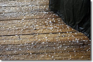
Weather Topic: What is Sleet?
Home - Education - Precipitation - Sleet
 Next Topic: Snow
Sleet is a form of precipitation in which small ice pellets are the primary
components. These ice pellets are smaller and more translucent than hailstones,
and harder than graupel. Sleet is caused by specific atmospheric conditions and
therefore typically doesn't last for extended periods of time.
The condition which leads to sleet formation requires a warmer body of air to be
wedged in between two sub-freezing bodies of air. When snow falls through a warmer
layer of air it melts, and as it falls through the next sub-freezing body of air
it freezes again, forming ice pellets known as sleet. In some cases, water
droplets don't have time to freeze before reaching the surface and the result is
freezing rain.
Next Topic: Snow
Current conditions powered by WeatherAPI.com


