Weather Alert in Alaska
Wind Advisory issued August 23 at 3:56PM AKDT until August 24 at 1:00AM AKDT by NWS Fairbanks AK
AREAS AFFECTED: South Slopes Of The Eastern Brooks Range; South Slopes Of The Central Brooks Range; Dalton Highway Summits; White Mountains and High Terrain South of the Yukon River; Upper Chena River Valley; Chatanika River Valley
DESCRIPTION: * WHAT...Southwest winds 20 to 30 mph with gusts up to 45 mph expected. The strongest winds are expected above 2000 feet elevation. * WHERE...Chatanika River Valley, Dalton Highway Summits, South Slopes Of The Central Brooks Range, South Slopes Of The Eastern Brooks Range, Upper Chena River Valley, and White Mountains and High Terrain South of the Yukon River. * WHEN...Until 1 AM AKDT Sunday. * IMPACTS...Gusty winds will blow around unsecured objects and may cause tree damage resulting in a few power outages. * ADDITIONAL DETAILS...These strong winds usher in a prolonged period of rainy weather so hunters and recreationists are encouraged to prepare for rising water levels on rivers and their tributaries.
INSTRUCTION: Winds this strong can make driving difficult, especially for high profile vehicles. Use extra caution.
Want more detail? Get the Complete 7 Day and Night Detailed Forecast!
Current U.S. National Radar--Current
The Current National Weather Radar is shown below with a UTC Time (subtract 5 hours from UTC to get Eastern Time).

National Weather Forecast--Current
The Current National Weather Forecast and National Weather Map are shown below.

National Weather Forecast for Tomorrow
Tomorrow National Weather Forecast and Tomorrow National Weather Map are show below.

North America Water Vapor (Moisture)
This map shows recent moisture content over North America. Bright and colored areas show high moisture (ie, clouds); brown indicates very little moisture present; black indicates no moisture.

Weather Topic: What is Condensation?
Home - Education - Precipitation - Condensation
 Next Topic: Contrails
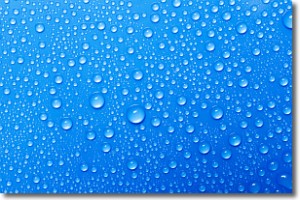
Condensation is the process which creates clouds, and therefore
it is a crucial process in the water cycle.
Condensation is the change of matter from a state of gas into a state of liquid,
and it happens because water molecules release heat into the atmosphere and
become organized into a more closely packed structure, what we might see as
water droplets.
Water is always present in the air around us as a vapor, but it's too small for
us to see. When water undergoes the process of condensation it becomes organized
into visible water droplets. You've probably seen condensation happen before on the
surface of a cold drink!
Next Topic: Contrails
Weather Topic: What are Cumulonimbus Clouds?
Home - Education - Cloud Types - Cumulonimbus Clouds
 Next Topic: Cumulus Clouds
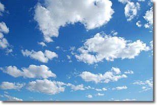
The final form taken by a growing cumulus cloud is the
cumulonimbus cloud, which is very tall and dense.
The tower of a cumulonimbus cloud can soar 23 km into the atmosphere, although
most commonly they stop growing at an altitude of 6 km.
Even small cumulonimbus clouds appear very large in comparison to other cloud types.
They can signal the approach of stormy weather, such as thunderstorms or blizzards.
Next Topic: Cumulus Clouds
Current conditions powered by WeatherAPI.com


