Weather Alert in Colorado
Red Flag Warning issued March 14 at 12:47AM MDT until March 14 at 8:00PM MDT by NWS Goodland KS
AREAS AFFECTED: Yuma; Kit Carson County; Cheyenne; Cheyenne; Rawlins; Decatur; Norton; Sherman; Thomas; Sheridan; Graham; Wallace; Logan; Gove; Greeley; Wichita; Dundy; Hitchcock; Red Willow
DESCRIPTION: ...Critical Fire Weather Conditions Forecast Today... Today, southwesterly winds are forecast through the day. Be aware of a strong cold front late evening with a wind shift to the north. Winds are forecast to increase with the front as well. Winds are forecast to gradually increase through the day. There is concern that cloud cover could impact the magnitude of winds; if that is not the case then winds could be stronger than forecast. * AFFECTED AREA...Fire Weather Zones 001 Cheyenne KS, 002 Rawlins, 003 Decatur, 004 Norton, 013 Sherman, 014 Thomas, 015 Sheridan, 016 Graham, 027 Wallace, 028 Logan, 029 Gove, 041 Greeley, 042 Wichita, 079 Dundy, 080 Hitchcock, 081 Red Willow, 252 Yuma, 253 Kit Carson and 254 Cheyenne CO. * TIMING...From 11 AM MDT /noon CDT/ this morning to 8 PM MDT /9 PM CDT/ this evening. * WINDS...Southwest 15 to 25 mph with gusts up to 40 mph. * RELATIVE HUMIDITY...As low as 9 percent. * IMPACTS...Unpredictable fire behavior. Any fires that develop may rapidly grow and spread out of control.
INSTRUCTION: Comply with burn bans and regulations. Avoid driving on dry grass or brush. Maintain vehicle brakes and tires and secure tow chains to avoid dragging. Never toss lit cigarettes onto the ground.
Want more detail? Get the Complete 7 Day and Night Detailed Forecast!
Current U.S. National Radar--Current
The Current National Weather Radar is shown below with a UTC Time (subtract 5 hours from UTC to get Eastern Time).

National Weather Forecast--Current
The Current National Weather Forecast and National Weather Map are shown below.

National Weather Forecast for Tomorrow
Tomorrow National Weather Forecast and Tomorrow National Weather Map are show below.

North America Water Vapor (Moisture)
This map shows recent moisture content over North America. Bright and colored areas show high moisture (ie, clouds); brown indicates very little moisture present; black indicates no moisture.

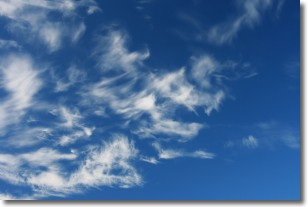
Weather Topic: What are Cirrostratus Clouds?
Home - Education - Cloud Types - Cirrostratus Clouds
 Next Topic: Cirrus Clouds
Cirrostratus clouds are high, thin clouds that form above
20,000 feet and are made mostly of ice crystals. They sometimes look like giant
feathers, horse tails, or curls of hair in the sky.
These clouds are pushed by the jet stream and can move at high speeds reaching
100 mph.
What do they indicate?
They indicate that a precipitation is likely within 24 hours.
Next Topic: Cirrus Clouds
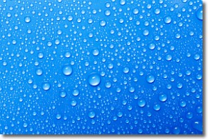
Weather Topic: What is Condensation?
Home - Education - Precipitation - Condensation
 Next Topic: Contrails
Condensation is the process which creates clouds, and therefore
it is a crucial process in the water cycle.
Condensation is the change of matter from a state of gas into a state of liquid,
and it happens because water molecules release heat into the atmosphere and
become organized into a more closely packed structure, what we might see as
water droplets.
Water is always present in the air around us as a vapor, but it's too small for
us to see. When water undergoes the process of condensation it becomes organized
into visible water droplets. You've probably seen condensation happen before on the
surface of a cold drink!
Next Topic: Contrails
Current conditions powered by WeatherAPI.com


