Weather Alert in Illinois
Tornado Watch issued March 15 at 2:42PM CDT until March 15 at 8:00PM CDT by NWS St Louis MO
AREAS AFFECTED: Bond, IL; Calhoun, IL; Clinton, IL; Fayette, IL; Greene, IL; Jersey, IL; Macoupin, IL; Madison, IL; Marion, IL; Monroe, IL; Montgomery, IL; Pike, IL; Randolph, IL; St. Clair, IL; Washington, IL; Crawford, MO; Franklin, MO; Gasconade, MO; Iron, MO; Jefferson, MO; Lincoln, MO; Madison, MO; Montgomery, MO; Osage, MO; Pike, MO; Reynolds, MO; St. Charles, MO; Ste. Genevieve, MO; St. Francois, MO; St. Louis, MO; Warren, MO; Washington, MO; St. Louis City, MO
DESCRIPTION: TORNADO WATCH 52 REMAINS VALID UNTIL 8 PM CDT THIS EVENING FOR THE FOLLOWING AREAS IN ILLINOIS THIS WATCH INCLUDES 15 COUNTIES IN SOUTH CENTRAL ILLINOIS BOND CLINTON FAYETTE MARION MONTGOMERY WASHINGTON IN SOUTHWEST ILLINOIS CALHOUN GREENE JERSEY MACOUPIN MADISON MONROE RANDOLPH SAINT CLAIR IN WEST CENTRAL ILLINOIS PIKE IN MISSOURI THIS WATCH INCLUDES 18 COUNTIES IN CENTRAL MISSOURI OSAGE IN EAST CENTRAL MISSOURI CRAWFORD FRANKLIN GASCONADE JEFFERSON LINCOLN MONTGOMERY SAINT CHARLES SAINT LOUIS SAINT LOUIS CITY WARREN WASHINGTON IN NORTHEAST MISSOURI PIKE IN SOUTHEAST MISSOURI IRON MADISON REYNOLDS SAINT FRANCOIS SAINTE GENEVIEVE THIS INCLUDES THE CITIES OF ALTON, BELLEVILLE, BOWLING GREEN, CAHOKIA, CENTRALIA, CHESTER, EDWARDSVILLE, FARMINGTON, LITCHFIELD, PITTSFIELD, SAINT CHARLES, SAINT LOUIS, SALEM, SPARTA, SULLIVAN, UNION, VANDALIA, AND WASHINGTON.
INSTRUCTION: N/A
Want more detail? Get the Complete 7 Day and Night Detailed Forecast!
Current U.S. National Radar--Current
The Current National Weather Radar is shown below with a UTC Time (subtract 5 hours from UTC to get Eastern Time).

National Weather Forecast--Current
The Current National Weather Forecast and National Weather Map are shown below.

National Weather Forecast for Tomorrow
Tomorrow National Weather Forecast and Tomorrow National Weather Map are show below.

North America Water Vapor (Moisture)
This map shows recent moisture content over North America. Bright and colored areas show high moisture (ie, clouds); brown indicates very little moisture present; black indicates no moisture.

Weather Topic: What are Wall Clouds?
Home - Education - Cloud Types - Wall Clouds
 Next Topic: Altocumulus Clouds
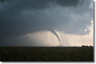
A wall cloud forms underneath the base of a cumulonimbus cloud,
and can be a hotbed for deadly tornadoes.
Wall clouds are formed by air flowing into the cumulonimbus clouds, which can
result in the wall cloud descending from the base of the cumulonimbus cloud, or
rising fractus clouds which join to the base of the storm cloud as the wall cloud
takes shape.
Wall clouds can be very large, and in the Northern Hemisphere they generally
form at the southern edge of cumulonimbus clouds.
Next Topic: Altocumulus Clouds
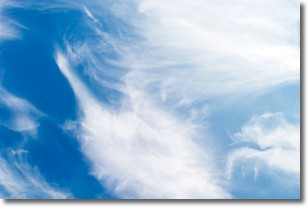
Weather Topic: What are Altostratus Clouds?
Home - Education - Cloud Types - Altostratus Clouds
 Next Topic: Cirrocumulus Clouds
Altostratus clouds form at mid to high-level altitudes
(between 2 and 7 km) and are created by a warm, stable air mass which causes
water vapor
to condense as it rise through the atmosphere. Usually altostratus clouds are
featureless sheets characterized by a uniform color.
In some cases, wind punching through the cloud formation may give it a waved
appearance, called altostratus undulatus. Altostratus clouds
are commonly seen with other cloud formations accompanying them.
Next Topic: Cirrocumulus Clouds
Current conditions powered by WeatherAPI.com


