Weather Alert in Alaska
Hydrologic Outlook issued August 22 at 1:07PM AKDT by NWS Fairbanks AK
AREAS AFFECTED: Howard Pass and the Delong Mountains; Central Brooks Range; South Slopes Of The Central Brooks Range; South Slopes of the Western Brooks Range; Noatak Valley; Lower Kobuk Valley; Northern Seward Peninsula; Upper Kobuk Valleys; Southern Seward Peninsula Coast; Interior Seward Peninsula; Eastern Norton Sound and Nulato Hills; Lower Yukon River; Lower Koyukuk Valley; Middle Yukon Valley; Lower Yukon and Innoko Valleys; Upper Koyukuk Valley; Dalton Highway Summits; Central Interior
DESCRIPTION: ESFAFG Multiple waves of rainfall are expected starting Saturday and continuing through early next week with rainfall totals exceeding 3 inches in many areas of the middle Kuskokwim, middle and lower Yukon, Koyukuk, and Kobuk River basins. Expect increasing river levels on tributaries to these basins starting this weekend and rising water levels on the main stems starting early next week. Highest rainfall totals could exceed 5 inches in isolated areas, typically at higher elevations in the Nulato Hills and the Brooks Range.
INSTRUCTION: N/A
Want more detail? Get the Complete 7 Day and Night Detailed Forecast!
Current U.S. National Radar--Current
The Current National Weather Radar is shown below with a UTC Time (subtract 5 hours from UTC to get Eastern Time).

National Weather Forecast--Current
The Current National Weather Forecast and National Weather Map are shown below.

National Weather Forecast for Tomorrow
Tomorrow National Weather Forecast and Tomorrow National Weather Map are show below.

North America Water Vapor (Moisture)
This map shows recent moisture content over North America. Bright and colored areas show high moisture (ie, clouds); brown indicates very little moisture present; black indicates no moisture.

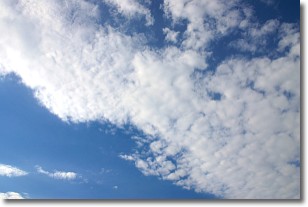
Weather Topic: What are Stratus Clouds?
Home - Education - Cloud Types - Stratus Clouds
 Next Topic: Wall Clouds
Stratus clouds are similar to altostratus clouds, but form at a
lower altitude and are identified by their fog-like appearance, lacking the
distinguishing features of most clouds.
Stratus clouds are wider than most clouds, and their base has a smooth, uniform
look which is lighter in color than a nimbostratus cloud.
The presence of a stratus cloud indicates the possibility of minor precipitation,
such as drizzle, but heavier precipitation does not typically arrive in the form
of a stratus cloud.
Next Topic: Wall Clouds
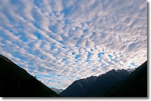
Weather Topic: What are Altocumulus Clouds?
Home - Education - Cloud Types - Altocumulus Clouds
 Next Topic: Altostratus Clouds
Similar to cirrocumulus clouds, altocumulus clouds are
characterized by cloud patches. They are distinguished by larger cloudlets
than cirrocumulus clouds but are still smaller than stratocumulus clouds.
Altocumulus clouds most commonly form in middle altitudes (between 2 and 5 km)
and may resemble, at times, the shape of a flying saucer.
These uncommon formations, called altocumulus lenticularis, are created by uplift
in the atmosphere and are most often seen in close proximity to mountains.
Next Topic: Altostratus Clouds
Current conditions powered by WeatherAPI.com


