Weather Alert in Nevada
Flood Advisory issued July 29 at 4:42PM PDT until July 29 at 7:45PM PDT by NWS Reno NV
AREAS AFFECTED: Douglas, NV
DESCRIPTION: * WHAT...Flooding caused by excessive rainfall is expected. * WHERE...A portion of western Nevada, including the following county, Douglas. * WHEN...Until 745 PM PDT. * IMPACTS...Minor flooding in low-lying and poor drainage areas. Some low-water crossings may become impassable. * ADDITIONAL DETAILS... - At 439 PM PDT, Doppler radar indicated heavy rain due to thunderstorms. Minor flooding is ongoing or expected to begin shortly in and near the Conner burn scar. Between 0.5 and 0.8 inches of rain have fallen. - The Conner burn scar, Pine Nut Creek, Buckeye Creek, and the East Fork of the Carson River south of Gardnerville Ranchos are the most likely places to experience minor flooding. - Some locations that will experience flooding include... Gardnerville, Gardnerville Ranchos and Junction U.S 395 And NV 756. - http://www.weather.gov/safety/flood
INSTRUCTION: Turn around, don't drown when encountering flooded roads. Most flood deaths occur in vehicles. Be aware of your surroundings and do not drive on flooded roads. Recent burn areas are more prone to flooding, debris flows, and rock falls. Plugged culverts, rocks and debris on roads, and water and mud over roads are common during moderate to heavy rains. Increased sediment and debris can lead to impacts in areas typically not prone to flooding. Use extra caution when traveling in or below recent burn areas. Impactful flooding and debris flows may be generated by 15 minutes or less of heavy rainfall.
Want more detail? Get the Complete 7 Day and Night Detailed Forecast!
Current U.S. National Radar--Current
The Current National Weather Radar is shown below with a UTC Time (subtract 5 hours from UTC to get Eastern Time).

National Weather Forecast--Current
The Current National Weather Forecast and National Weather Map are shown below.

National Weather Forecast for Tomorrow
Tomorrow National Weather Forecast and Tomorrow National Weather Map are show below.

North America Water Vapor (Moisture)
This map shows recent moisture content over North America. Bright and colored areas show high moisture (ie, clouds); brown indicates very little moisture present; black indicates no moisture.

Weather Topic: What is Drizzle?
Home - Education - Precipitation - Drizzle
 Next Topic: Evaporation
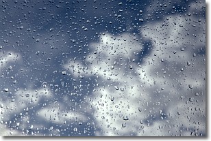
Drizzle is precipitation in the form of water droplets which are
smaller than raindrops.
Drizzle is characterized by fine, gently falling droplets and typically does not
impact human habitation in a negative way. The exception to this is freezing drizzle,
a condition where drizzle freezes immediately upon reaching earth's surface.
Freezing drizzle is still less dangerous than freezing rain, but can
potentially result in hazardous road conditions.
Next Topic: Evaporation
Weather Topic: What is Fog?
Home - Education - Cloud Types - Fog
 Next Topic: Fractus Clouds
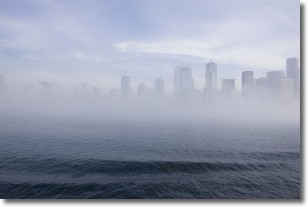
Fog is technically a type of stratus cloud, which lies along the
ground and obscures visibility.
It is usually created when humidity in the air condenses into tiny water droplets.
Because of this, some places are more prone to foggy weather, such as regions
close to a body of water.
Fog is similar to mist; both are the appearance of water droplets suspended in
the air, but fog is the term applied to the condition when visibility is less than 1 km.
Next Topic: Fractus Clouds
Current conditions powered by WeatherAPI.com


