Weather Alert in Texas
Red Flag Warning issued March 14 at 12:00PM CDT until March 16 at 8:00PM CDT by NWS Austin/San Antonio TX
AREAS AFFECTED: Llano; Burnet; Williamson; Val Verde; Edwards; Real; Kerr; Bandera; Gillespie; Kendall; Blanco; Hays; Travis; Bastrop; Lee; Kinney; Uvalde; Medina; Bexar; Comal; Guadalupe; Caldwell; Fayette; Maverick; Zavala; Frio; Atascosa; Wilson; Karnes; Gonzales; De Witt; Lavaca; Dimmit
DESCRIPTION: ...CRITICAL FIRE WEATHER CONDITIONS SUNDAY THROUGH MONDAY... .Strong to very strong winds and dry air associated with both a dryline and cold front will result in a prolonged period of critical fire weather conditions across South-Central Texas on Sunday through Monday. The National Weather Service in Austin/San Antonio has issued a Red Flag Warning for wind and low relative humidity, which is in effect from Sunday afternoon through Monday evening. The Fire Weather Watch is no longer in effect. * AFFECTED AREA...All of South-Central Texas. * TIMING...From Sunday afternoon through Monday evening. * WINDS...West 10 to 20 mph with gusts to 35 mph Sunday afternoon becoming North 20 to 35 mph with gusts of 45 to 55 mph Sunday evening into Sunday night. * RELATIVE HUMIDITY...10 to 25 percent Sunday and Monday afternoons. Poor overnight recovery during Sunday night with humidity rising only to near the 25 to 35 percent range. * IMPACTS...Any fire that develops will catch and spread rapidly. Outdoor burning is not recommended.
INSTRUCTION: A Red Flag Warning means that critical fire weather conditions are either occurring now....or will shortly. A combination of strong winds...low relative humidity...and warm temperatures can contribute to extreme fire behavior.
Want more detail? Get the Complete 7 Day and Night Detailed Forecast!
Current U.S. National Radar--Current
The Current National Weather Radar is shown below with a UTC Time (subtract 5 hours from UTC to get Eastern Time).

National Weather Forecast--Current
The Current National Weather Forecast and National Weather Map are shown below.

National Weather Forecast for Tomorrow
Tomorrow National Weather Forecast and Tomorrow National Weather Map are show below.

North America Water Vapor (Moisture)
This map shows recent moisture content over North America. Bright and colored areas show high moisture (ie, clouds); brown indicates very little moisture present; black indicates no moisture.

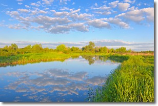
Weather Topic: What are Stratocumulus Clouds?
Home - Education - Cloud Types - Stratocumulus Clouds
 Next Topic: Stratus Clouds
Stratocumulus clouds are similar to altocumulus clouds in their
fluffy appearance, but have a slightly darker shade due to their additional mass.
A good way to distinguish the two cloud types is to hold your hand out and measure
the size of an individual cloud; if it is the size of your thumb it is generally
an altocumulus cloud, if it is the size of your hand it is generally a
stratocumulus cloud.
It is uncommon for stratocumulus clouds to produce precipitation, but if they do
it is usually a light rain or snow.
Next Topic: Stratus Clouds
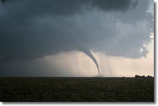
Weather Topic: What are Wall Clouds?
Home - Education - Cloud Types - Wall Clouds
 Next Topic: Altocumulus Clouds
A wall cloud forms underneath the base of a cumulonimbus cloud,
and can be a hotbed for deadly tornadoes.
Wall clouds are formed by air flowing into the cumulonimbus clouds, which can
result in the wall cloud descending from the base of the cumulonimbus cloud, or
rising fractus clouds which join to the base of the storm cloud as the wall cloud
takes shape.
Wall clouds can be very large, and in the Northern Hemisphere they generally
form at the southern edge of cumulonimbus clouds.
Next Topic: Altocumulus Clouds
Current conditions powered by WeatherAPI.com


