Weather Alert in Idaho
Flood Warning issued March 14 at 8:48AM PDT until March 15 at 7:48AM PDT by NWS Spokane WA
AREAS AFFECTED: Latah, ID; Whitman, WA
DESCRIPTION: ...Observed flooding increased in duration for the following rivers in Washington...Idaho... Paradise Creek at Moscow affecting Latah and Whitman Counties. For the Paradise Creek ...including Moscow...Moderate flooding is forecast. * WHAT...Record flooding is occurring. * WHERE...Paradise Creek at Moscow. * WHEN...Until tomorrow morning. * IMPACTS...At 11.3 feet, Flooding will increase across many streets and impact homes in the flood plain, including the intersection of E and Harding street, Lemhi at Mountain View street, Blaine at White street, and portions of the University of Idaho campus. Similar to the flooding of 2019. * ADDITIONAL DETAILS... - At 7:45 AM PDT Saturday the stage was 11.5 feet. - Bankfull stage is 8.0 feet. - Recent Activity...The maximum river stage in the 24 hours ending at 7:45 AM PDT Saturday was 11.5 feet. - Forecast...The river is expected to recede into its minor flood stage by Saturday afternoon and into its action stage by Sunday morning. It is forecasted to remain in action stage through Monday. - Flood stage is 9.2 feet. - Flood History...This crest compares to a previous crest of 11.4 feet on 04/09/2019. - http://www.weather.gov/safety/flood
INSTRUCTION: Turn around, don't drown when encountering flooded roads. Most flood deaths occur in vehicles. Caution is urged when walking near riverbanks. Motorists should not attempt to drive around barricades or drive cars through flooded areas. Additional information is available at www.weather.gov. The next statement will be issued this evening at 930 PM PDT.
Want more detail? Get the Complete 7 Day and Night Detailed Forecast!
Current U.S. National Radar--Current
The Current National Weather Radar is shown below with a UTC Time (subtract 5 hours from UTC to get Eastern Time).

National Weather Forecast--Current
The Current National Weather Forecast and National Weather Map are shown below.

National Weather Forecast for Tomorrow
Tomorrow National Weather Forecast and Tomorrow National Weather Map are show below.

North America Water Vapor (Moisture)
This map shows recent moisture content over North America. Bright and colored areas show high moisture (ie, clouds); brown indicates very little moisture present; black indicates no moisture.

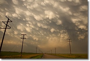
Weather Topic: What are Mammatus Clouds?
Home - Education - Cloud Types - Mammatus Clouds
 Next Topic: Nimbostratus Clouds
A mammatus cloud is a cloud with a unique feature which resembles
a web of pouches hanging along the base of the cloud.
In the United States, mammatus clouds tend to form in the warmer months, commonly
in the Midwest and eastern regions.
While they usually form at the bottom of a cumulonimbis cloud, they can also form
under altostratus, altocumulus, stratocumulus, and cirrus clouds. Mammatus clouds
warn that severe weather is close.
Next Topic: Nimbostratus Clouds
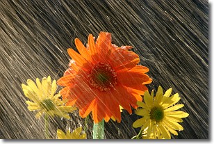
Weather Topic: What is Precipitation?
Home - Education - Precipitation - Precipitation
 Next Topic: Rain
Precipitation can refer to many different forms of water that
may fall from clouds. Precipitation occurs after a cloud has become saturated to
the point where its water particles are more dense than the air below the cloud.
In most cases, precipitation will reach the ground, but it is not uncommon for
precipitation to evaporate before it reaches the earth's surface.
When precipitation evaporates before it contacts the ground it is called Virga.
Graupel, hail, sleet, rain, drizzle, and snow are forms of precipitation, but fog
and mist are not considered precipitation because the water vapor which
constitutes them isn't dense enough to fall to the ground.
Next Topic: Rain
Current conditions powered by WeatherAPI.com


