Weather Alert in Georgia
Flood Watch issued August 23 at 3:42AM EDT until August 24 at 2:00AM EDT by NWS Charleston SC
AREAS AFFECTED: Jenkins; Screven; Candler; Bulloch; Effingham; Tattnall; Evans; Inland Bryan; Coastal Bryan; Inland Chatham; Coastal Chatham; Long; Inland Liberty; Coastal Liberty; Inland McIntosh; Coastal McIntosh; Allendale; Hampton; Inland Colleton; Dorchester; Inland Berkeley; Inland Jasper; Beaufort; Coastal Colleton; Charleston; Coastal Jasper; Tidal Berkeley
DESCRIPTION: * WHAT...Flash flooding caused by excessive rainfall continues to be possible. * WHERE...Portions of southeast Georgia, including the following areas, Bulloch, Candler, Coastal Bryan, Coastal Chatham, Coastal Liberty, Coastal McIntosh, Effingham, Evans, Inland Bryan, Inland Chatham, Inland Liberty, Inland McIntosh, Jenkins, Long, Screven and Tattnall and southeast South Carolina, including the following areas, Allendale, Beaufort, Charleston, Coastal Colleton, Coastal Jasper, Dorchester, Hampton, Inland Berkeley, Inland Colleton, Inland Jasper and Tidal Berkeley. * WHEN...Through late tonight. * IMPACTS...Excessive runoff may result in flooding of rivers, creeks, streams, and other low-lying and flood-prone locations. Creeks and streams may rise out of their banks. Flooding may occur in poor drainage and urban areas. Storm drains and ditches may become clogged with debris. Extensive street flooding and flooding of creeks and rivers are possible. * ADDITIONAL DETAILS... - Showers and thunderstorms produced numerous areas of 3 to 5 inches, with localized areas receiving in excess of 7 inches, of rainfall on Friday across southeast Georgia and the South Carolina. An additional 1.5 to 2.5 inches of rainfall can be expected across the region through this evening. The heaviest rainfall should occur generally along and east of the Interstate 95 corridor, some areas possibly receiving in excess of 4 inches. The additional rainfall falling on nearly saturated soil will likely lead to rapid runoff, possibly producing flash flooding. Several streams and creeks have elevated water levels following the heavy rainfall that occurred on Friday. Based on the forecast rainfall, Church Creek near West Ashley, French Quarter Creek near Huger, and Ireland Creek at Walterboro could see water levels crest above flood stage. In addition, flash flooding may develop within coastal cities with any heavy downpours that coincide with high tide this morning or this evening. - http://www.weather.gov/safety/flood
INSTRUCTION: Be prepared to protect life and property, especially in areas prone to flooding. If flooding develops, move to higher ground immediately. If driving, be prepared for flooded roadways and possible road closures.
Want more detail? Get the Complete 7 Day and Night Detailed Forecast!
Current U.S. National Radar--Current
The Current National Weather Radar is shown below with a UTC Time (subtract 5 hours from UTC to get Eastern Time).

National Weather Forecast--Current
The Current National Weather Forecast and National Weather Map are shown below.

National Weather Forecast for Tomorrow
Tomorrow National Weather Forecast and Tomorrow National Weather Map are show below.

North America Water Vapor (Moisture)
This map shows recent moisture content over North America. Bright and colored areas show high moisture (ie, clouds); brown indicates very little moisture present; black indicates no moisture.

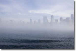
Weather Topic: What is Fog?
Home - Education - Cloud Types - Fog
 Next Topic: Fractus Clouds
Fog is technically a type of stratus cloud, which lies along the
ground and obscures visibility.
It is usually created when humidity in the air condenses into tiny water droplets.
Because of this, some places are more prone to foggy weather, such as regions
close to a body of water.
Fog is similar to mist; both are the appearance of water droplets suspended in
the air, but fog is the term applied to the condition when visibility is less than 1 km.
Next Topic: Fractus Clouds
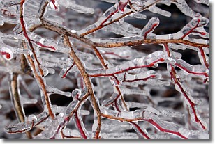
Weather Topic: What is Freezing Rain?
Home - Education - Precipitation - Freezing Rain
 Next Topic: Graupel
Freezing rain is a condition where precipitation which has fallen in the form of
water droplets reaches temperatures which are below freezing and freezes upon
coming into contact
with surface objects. The result of this precipitation is a glaze of ice which
can be damaging to plants and man-made structures. A severe onset of freezing
rain which results in a very thick glaze of ice is known as an ice storm.
Next Topic: Graupel
Current conditions powered by WeatherAPI.com


