Weather Alert in Texas
Air Quality Alert issued July 28 at 5:40PM CDT by NWS Houston/Galveston TX
AREAS AFFECTED: Inland Harris; Inland Brazoria; Inland Galveston; Coastal Harris; Coastal Brazoria; Coastal Galveston; Brazoria Islands; Galveston Island; Bolivar Peninsula
DESCRIPTION: AQAHGX The Texas Commission on Environmental Quality (TCEQ) has issued an Ozone Action Day for the Houston, Galveston, and Brazoria area for Tuesday, July 29, 2025. Atmospheric conditions are expected to be favorable for producing high levels of ozone pollution in the Houston, Galveston, and surrounding areas on Tuesday. You can help prevent ozone pollution by sharing a ride, walking, riding a bicycle, taking your lunch to work, avoiding drive through lanes, conserving energy and keeping your vehicle properly tuned. For more information on ozone: Ozone: The Facts www.tceq.texas.gov/airquality/monops/ozonefacts.html EPA AirNow: www.airnow.gov/?city=Houston&state=TX&country=USA Take Care of Texas: www.takecareoftexas.org/conservation-tips/keep-our-air-clean
INSTRUCTION: N/A
Want more detail? Get the Complete 7 Day and Night Detailed Forecast!
Current U.S. National Radar--Current
The Current National Weather Radar is shown below with a UTC Time (subtract 5 hours from UTC to get Eastern Time).

National Weather Forecast--Current
The Current National Weather Forecast and National Weather Map are shown below.

National Weather Forecast for Tomorrow
Tomorrow National Weather Forecast and Tomorrow National Weather Map are show below.

North America Water Vapor (Moisture)
This map shows recent moisture content over North America. Bright and colored areas show high moisture (ie, clouds); brown indicates very little moisture present; black indicates no moisture.

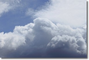
Weather Topic: What are Nimbostratus Clouds?
Home - Education - Cloud Types - Nimbostratus Clouds
 Next Topic: Precipitation
A nimbostratus cloud is similar to a stratus cloud in its formless,
smooth appearance. However, a nimbostratus cloud is darker than a stratus cloud,
because it is thicker.
Unlike a stratus cloud, a nimbostratus cloud typically brings with it the threat
of moderate to heavy precipitation. In some cases, the precipitation may evaporate
before reaching the ground, a phenomenon known as virga.
Next Topic: Precipitation
Weather Topic: What is Rain?
Home - Education - Precipitation - Rain
 Next Topic: Shelf Clouds
Precipitation in the form of water droplets is called rain.
Rain generally has a tendency to fall with less intensity over a greater period
of time, and when rainfall is more severe it is usually less sustained.
Rain is the most common form of precipitation and happens with greater frequency
depending on the season and regional influences. Cities have been shown to have
an observable effect on rainfall, due to an effect called the urban heat island.
Compared to upwind, monthly rainfall between twenty and forty miles downwind of
cities is 30% greater.
Next Topic: Shelf Clouds
Current conditions powered by WeatherAPI.com


