Weather Alert in Minnesota
Flood Warning issued August 22 at 9:51AM CDT by NWS Twin Cities/Chanhassen MN
AREAS AFFECTED: Chippewa, MN; Lac qui Parle, MN; Yellow Medicine, MN
DESCRIPTION: ...The National Weather Service in the Twin Cities has issued a Flood Warning for the following rivers in Minnesota... Minnesota River at Henderson MN19 affecting Sibley, Le Sueur and Scott Counties. Minnesota River near Jordan affecting Sibley, Scott and Carver Counties. ...Forecast flooding changed from Minor to Moderate severity for the following rivers in Minnesota... Minnesota River at Montevideo affecting Chippewa, Yellow Medicine and Lac qui Parle Counties. .As water from storms over the past few weeks continue to move through the Minnesota River more points will rise above flood stage. Based on current forecasts additional warnings downriver are not anticipated. * WHAT...Minor flooding is occurring and moderate flooding is forecast. * WHERE...Minnesota River at Montevideo. * WHEN...Until further notice. * IMPACTS...At 17.0 feet, Storm sewers may need to be plugged to prevent water from backing up into streets. * ADDITIONAL DETAILS... - At 900 AM CDT Friday, the stage was 16.0 feet. - Recent Activity...The maximum river stage in the 24 hours ending at 900 AM CDT Friday was 16.0 feet. - Forecast...The river is expected to maintain a crest of 16.0 feet this afternoon. - Flood stage is 14.0 feet. - Flood History...This crest compares to a previous crest of 16.0 feet on 03/25/1994.
INSTRUCTION: Turn around, don't drown when encountering flooded roads. Most flood deaths occur in vehicles. Please report observed flooding to local emergency services or law enforcement and request they pass this information to the National Weather Service when you can do so safely.
Want more detail? Get the Complete 7 Day and Night Detailed Forecast!
Current U.S. National Radar--Current
The Current National Weather Radar is shown below with a UTC Time (subtract 5 hours from UTC to get Eastern Time).

National Weather Forecast--Current
The Current National Weather Forecast and National Weather Map are shown below.

National Weather Forecast for Tomorrow
Tomorrow National Weather Forecast and Tomorrow National Weather Map are show below.

North America Water Vapor (Moisture)
This map shows recent moisture content over North America. Bright and colored areas show high moisture (ie, clouds); brown indicates very little moisture present; black indicates no moisture.

Weather Topic: What are Cumulonimbus Clouds?
Home - Education - Cloud Types - Cumulonimbus Clouds
 Next Topic: Cumulus Clouds
The final form taken by a growing cumulus cloud is the
cumulonimbus cloud, which is very tall and dense.
The tower of a cumulonimbus cloud can soar 23 km into the atmosphere, although
most commonly they stop growing at an altitude of 6 km.
Even small cumulonimbus clouds appear very large in comparison to other cloud types.
They can signal the approach of stormy weather, such as thunderstorms or blizzards.
Next Topic: Cumulus Clouds
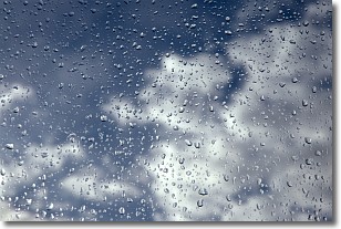
Weather Topic: What is Drizzle?
Home - Education - Precipitation - Drizzle
 Next Topic: Evaporation
Drizzle is precipitation in the form of water droplets which are
smaller than raindrops.
Drizzle is characterized by fine, gently falling droplets and typically does not
impact human habitation in a negative way. The exception to this is freezing drizzle,
a condition where drizzle freezes immediately upon reaching earth's surface.
Freezing drizzle is still less dangerous than freezing rain, but can
potentially result in hazardous road conditions.
Next Topic: Evaporation
Current conditions powered by WeatherAPI.com


