Weather Alert in Idaho
Avalanche Warning issued March 14 at 7:07AM PDT by NWS Spokane WA
AREAS AFFECTED: Shoshone, ID
DESCRIPTION: AVWOTX The Idaho Panhandle Avalanche Center in Sandpoint has issued a BACKCOUNTRY AVALANCHE WARNING for the following areas: NWS Missoula MT - MTZ001 (MTZ001) NWS Spokane WA - ID 079 (Shoshone County) * WHAT...An Avalanche Warning is in effect from Saturday 7 AM PDT to Sunday 7 AM PDT. Very dangerous avalanche conditions developed Wednesday night from heavy snowfall and strong to extreme winds, and these hazardous conditions are lasting through Sunday due to continued heavy snowfall in specific locations and sustained winds strong enough to transport the abundant new snow. A person's weight or a rider on a machine can very easily trigger avalanches large enough to bury or kill them, and some slides will release naturally. * WHERE...The Bitterroot Mountains - Silver Valley and the East Cabinet Mountains above 4,000 feet. * WHEN...In effect from Sat 07:00 PDT to Sun 07:00 PDT. * IMPACTS...An atmospheric river and violent jet stream joined forces to deliver heavy snowfall and strong to extreme winds to the Inland Northwest. Wind speeds peaked on Wednesday night and have subsided considerably since then, however an uptick is expected on Saturday with gusts reaching 40 to 50 mph possible. The sustained moderate to heavy snowfall is being measured in multiple feet at higher elevations and winds are forecasted to remain strong enough to cause significant transport and redistribution of snow. The recent snowfall has formed dangerous slabs of snow and will likely cause a widespread cycle of natural avalanches large enough to bury, injure, or kill a person. * PRECAUTIONARY / PREPAREDNESS ACTIONS...Very dangerous avalanche conditions exist in the mountains and widespread areas of unstable snow are expected. The largest slides may run long distances and can run into mature forests, valley floors, or flat terrain. Travel in or near avalanche terrain is not recommended and should be avoided during this period of significant instability. Consult http://www.idahopanhandleavalanche.org/ or www.avalanche.org for more detailed information. Similar avalanche danger may exist at locations outside the coverage area of this or any avalanche center.
INSTRUCTION: N/A
Want more detail? Get the Complete 7 Day and Night Detailed Forecast!
Current U.S. National Radar--Current
The Current National Weather Radar is shown below with a UTC Time (subtract 5 hours from UTC to get Eastern Time).

National Weather Forecast--Current
The Current National Weather Forecast and National Weather Map are shown below.

National Weather Forecast for Tomorrow
Tomorrow National Weather Forecast and Tomorrow National Weather Map are show below.

North America Water Vapor (Moisture)
This map shows recent moisture content over North America. Bright and colored areas show high moisture (ie, clouds); brown indicates very little moisture present; black indicates no moisture.

Weather Topic: What is Freezing Rain?
Home - Education - Precipitation - Freezing Rain
 Next Topic: Graupel
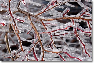
Freezing rain is a condition where precipitation which has fallen in the form of
water droplets reaches temperatures which are below freezing and freezes upon
coming into contact
with surface objects. The result of this precipitation is a glaze of ice which
can be damaging to plants and man-made structures. A severe onset of freezing
rain which results in a very thick glaze of ice is known as an ice storm.
Next Topic: Graupel
Weather Topic: What is Hail?
Home - Education - Precipitation - Hail
 Next Topic: Hole Punch Clouds
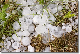
Hail is a form of precipitation which is recognized by large solid balls or
clumps of ice. Hail is created by thunderstorm clouds with strong updrafts of wind.
As the hailstones remain in the updraft, ice is deposited onto them until their
weight becomes heavy enough for them to fall to the earth's surface.
Hail storms can cause significant damage to crops, aircrafts, and man-made structures,
despite the fact that the duration is usually less than ten minutes.
Next Topic: Hole Punch Clouds
Current conditions powered by WeatherAPI.com


