Weather Alert in Alaska
Flood Advisory issued August 2 at 3:46PM AKDT until August 3 at 6:00PM AKDT by NWS Anchorage AK
AREAS AFFECTED: Lower Matanuska Valley; Sutton / Upper Matanuska Valley
DESCRIPTION: * WHAT...Flooding caused by excessive rainfall is expected. * WHERE...Matanuska River. * WHEN...Until 600 PM AKDT Sunday. * IMPACTS...River levels have exceeded those observed in early July, and increased bank erosion expected along the lower Matanuska River. While water levels may rise in small streams and rivers across the Matanuska-Susitna Valley, flooding is not expected west of the lower Matanuska River. Minor flooding in low-lying and poor drainage areas. Possible isolated landslides in areas of steep terrain primarily between Sutton and Eureka. * ADDITIONAL DETAILS... - At 336 PM AKDT, river gauge reports indicate rises in water levels from heavy rain in the advisory area. Minor flooding is ongoing or expected to begin shortly, especially near Matanuska River. Between 1.5 and 2 inches of rain have fallen. - - For Matanuska River at Palmer: At 2:30pm the stage was 28600.0 cfs. Forecast: A crest around 34016.8 cfs is expected around 10:00pm Saturday. Impacts: At 15000.0 cfs: Action Flow - This discharge (flow) level represents the higher end of the typical summertime range, and will likely be reached at least once nearly every year. Localized minor out-of-bank flooding may start to occur along parts of the Glenn highway, especially east of Sutton from milepost 64 to 66. At 30000.0 cfs: Minor Flood Flow - This discharge (flow) level has a roughly 20 percent chance of being reached in any given year. Additional vulnerable locations near the active river channel may experience some flooding at this level west of the Old Glenn Highway in the Butte and near Sutton from Milepost 64 to 66. Residents are advised that for the past several years at both of these locations, the main channel of the river has been shifting closer to the bank. At 35000.0 cfs: Moderate Flood Flow - This discharge (flow) level has a roughly 10 percent chance of being reached in any given year. Flooding near vulnerable locations along the active river channel may become more significant and widespread. This level was reached during the flooding in 2012. - For Moose Creek near Palmer: At 2:45pm the stage was 16.0 feet. Flood Stage is 17.5 feet. - http://www.weather.gov/safety/flood - If you live near or along the Matanuska River near Palmer or Butte stay alert and be prepared to take action.
INSTRUCTION: Stay tuned to further developments by listening to your local radio, television, or NOAA Weather Radio for further information.
Want more detail? Get the Complete 7 Day and Night Detailed Forecast!
Current U.S. National Radar--Current
The Current National Weather Radar is shown below with a UTC Time (subtract 5 hours from UTC to get Eastern Time).

National Weather Forecast--Current
The Current National Weather Forecast and National Weather Map are shown below.

National Weather Forecast for Tomorrow
Tomorrow National Weather Forecast and Tomorrow National Weather Map are show below.

North America Water Vapor (Moisture)
This map shows recent moisture content over North America. Bright and colored areas show high moisture (ie, clouds); brown indicates very little moisture present; black indicates no moisture.

Weather Topic: What are Altocumulus Clouds?
Home - Education - Cloud Types - Altocumulus Clouds
 Next Topic: Altostratus Clouds
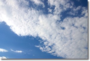
Similar to cirrocumulus clouds, altocumulus clouds are
characterized by cloud patches. They are distinguished by larger cloudlets
than cirrocumulus clouds but are still smaller than stratocumulus clouds.
Altocumulus clouds most commonly form in middle altitudes (between 2 and 5 km)
and may resemble, at times, the shape of a flying saucer.
These uncommon formations, called altocumulus lenticularis, are created by uplift
in the atmosphere and are most often seen in close proximity to mountains.
Next Topic: Altostratus Clouds
Weather Topic: What are Cirrocumulus Clouds?
Home - Education - Cloud Types - Cirrocumulus Clouds
 Next Topic: Cirrostratus Clouds
Cirrocumulus clouds form at high altitudes (usually around 5 km)
and have distinguishing characteristics displayed in a fine layer of
small cloud patches. These small cloud patches are sometimes referred to as
"cloudlets" in relation to the whole cloud formation.
Cirrocumulus clouds are formed from ice crystals and water droplets. Often, the
water droplets in the cloud freeze into ice crystals and the cloud becomes a
cirrostratus cloud. Because of this common occurrence, cirrocumulus cloud
formations generally pass rapidly.
Next Topic: Cirrostratus Clouds
Current conditions powered by WeatherAPI.com


