Weather Alert in Idaho
Heat Advisory issued August 22 at 10:56AM PDT until August 27 at 9:00PM PDT by NWS Spokane WA
AREAS AFFECTED: Coeur d'Alene Area; Idaho Palouse; Lewis and Southern Nez Perce Counties; Northeast Blue Mountains; Washington Palouse; Spokane Area; Northeast Mountains; Okanogan Highlands
DESCRIPTION: * WHAT...Hot temperatures. High temperatures 90 to 99 degrees for elevations below 3500 feet. High temperatures 80 to 89 degrees for elevations above 3500 feet. Limited overnight relief with low temperatures 57 to 65. * WHERE...Post Falls, Kamiah, Soldiers Meadow Road, Peola, Davenport, Worley, Craigmont, Sherman Pass, Anatone, Airway Heights, Boulder Creek Road, Metaline Falls, Colfax, Moscow, Genesee, La Crosse, Metaline, Republic, Tiger, Tekoa, Plummer, Coeur d'Alene, Uniontown, Flowery Trail Road, Cloverland Road, Deer Park, Rosalia, Chewelah, Fruitland, Colville, Newport, Kettle Falls, Springdale-Hunters Road, Chesaw Road, Inchelium, Orin-Rice Road, Oakesdale, Mountain Road, Highway 20 Wauconda Summit, Nezperce, Wauconda, Spokane Valley, Potlatch, Winchester, Rockford, Downtown Spokane, Pullman, Hayden, Northport, Ione, Cheney, and Fairfield. * WHEN...From noon Saturday to 9 PM PDT Wednesday. * IMPACTS...Hot temperatures will increase the risk of heat-related illnesses. Heat of this magnitude affects anyone without cooling and hydration as well as health systems and industries.
INSTRUCTION: Drink plenty of fluids, stay in an air-conditioned room, stay out of the sun, and check up on relatives and neighbors. Take extra precautions when outside. Wear lightweight and loose fitting clothing. Try to limit strenuous activities to early morning or evening. Take action when you see symptoms of heat exhaustion and heat stroke. To reduce risk during outdoor work, the Occupational Safety and Health Administration recommends scheduling frequent rest breaks in shaded or air conditioned environments. Anyone overcome by heat should be moved to a cool and shaded location. Heat stroke is an emergency! Call 9 1 1.
Want more detail? Get the Complete 7 Day and Night Detailed Forecast!
Current U.S. National Radar--Current
The Current National Weather Radar is shown below with a UTC Time (subtract 5 hours from UTC to get Eastern Time).

National Weather Forecast--Current
The Current National Weather Forecast and National Weather Map are shown below.

National Weather Forecast for Tomorrow
Tomorrow National Weather Forecast and Tomorrow National Weather Map are show below.

North America Water Vapor (Moisture)
This map shows recent moisture content over North America. Bright and colored areas show high moisture (ie, clouds); brown indicates very little moisture present; black indicates no moisture.

Weather Topic: What is Rain?
Home - Education - Precipitation - Rain
 Next Topic: Shelf Clouds
Precipitation in the form of water droplets is called rain.
Rain generally has a tendency to fall with less intensity over a greater period
of time, and when rainfall is more severe it is usually less sustained.
Rain is the most common form of precipitation and happens with greater frequency
depending on the season and regional influences. Cities have been shown to have
an observable effect on rainfall, due to an effect called the urban heat island.
Compared to upwind, monthly rainfall between twenty and forty miles downwind of
cities is 30% greater.
Next Topic: Shelf Clouds
Weather Topic: What is Sleet?
Home - Education - Precipitation - Sleet
 Next Topic: Snow
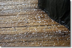
Sleet is a form of precipitation in which small ice pellets are the primary
components. These ice pellets are smaller and more translucent than hailstones,
and harder than graupel. Sleet is caused by specific atmospheric conditions and
therefore typically doesn't last for extended periods of time.
The condition which leads to sleet formation requires a warmer body of air to be
wedged in between two sub-freezing bodies of air. When snow falls through a warmer
layer of air it melts, and as it falls through the next sub-freezing body of air
it freezes again, forming ice pellets known as sleet. In some cases, water
droplets don't have time to freeze before reaching the surface and the result is
freezing rain.
Next Topic: Snow
Current conditions powered by WeatherAPI.com


