Weather Alert in Indiana
Flood Warning issued March 14 at 12:47PM EDT until March 15 at 6:00AM EDT by NWS Indianapolis IN
AREAS AFFECTED: Jackson, IN; Lawrence, IN; Washington, IN
DESCRIPTION: ...The Flood Warning continues for the following rivers in Indiana... East Fork White River at Seymour. . Minor Flooding on the East Fork White River around Seymour will end Sunday morning. Minor flooding is then likely again starting the middle of next week. * WHAT...Minor flooding is occurring and minor flooding is forecast. * WHERE...East Fork White River at Seymour. * WHEN...Until tomorrow morning. * IMPACTS...At 14.0 feet, Pasture lands, agricultural lands and several county and state roads begin to flood. High water isolates a few river cabins. State Road 235 east of Medora and county roads near Shields and Vallonia flood. Roads that begin to flood include SR 258 east of Cortland, CR 725 N just north of the gaging site and Ewing Road near Brownstown. * ADDITIONAL DETAILS... - At 11:45 AM EDT Saturday the stage was 14.3 feet. - Recent Activity...The maximum river stage in the 24 hours ending at 11:45 AM EDT Saturday was 16.0 feet. - Forecast...The river will fall below flood stage tomorrow morning. - Flood stage is 12.0 feet. - http://www.weather.gov/safety/flood
INSTRUCTION: Motorists should not attempt to drive around barricades or drive cars through flooded areas. Additional information is available at www.weather.gov/ind. The next statement should be issued Sunday morning by around 600 AM EDT.
Want more detail? Get the Complete 7 Day and Night Detailed Forecast!
Current U.S. National Radar--Current
The Current National Weather Radar is shown below with a UTC Time (subtract 5 hours from UTC to get Eastern Time).

National Weather Forecast--Current
The Current National Weather Forecast and National Weather Map are shown below.

National Weather Forecast for Tomorrow
Tomorrow National Weather Forecast and Tomorrow National Weather Map are show below.

North America Water Vapor (Moisture)
This map shows recent moisture content over North America. Bright and colored areas show high moisture (ie, clouds); brown indicates very little moisture present; black indicates no moisture.

Weather Topic: What is Drizzle?
Home - Education - Precipitation - Drizzle
 Next Topic: Evaporation
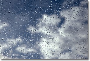
Drizzle is precipitation in the form of water droplets which are
smaller than raindrops.
Drizzle is characterized by fine, gently falling droplets and typically does not
impact human habitation in a negative way. The exception to this is freezing drizzle,
a condition where drizzle freezes immediately upon reaching earth's surface.
Freezing drizzle is still less dangerous than freezing rain, but can
potentially result in hazardous road conditions.
Next Topic: Evaporation
Weather Topic: What is Fog?
Home - Education - Cloud Types - Fog
 Next Topic: Fractus Clouds
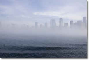
Fog is technically a type of stratus cloud, which lies along the
ground and obscures visibility.
It is usually created when humidity in the air condenses into tiny water droplets.
Because of this, some places are more prone to foggy weather, such as regions
close to a body of water.
Fog is similar to mist; both are the appearance of water droplets suspended in
the air, but fog is the term applied to the condition when visibility is less than 1 km.
Next Topic: Fractus Clouds
Current conditions powered by WeatherAPI.com


