Weather Alert in Illinois
Flood Warning issued March 14 at 9:53PM EDT until March 22 at 5:00AM EDT by NWS Indianapolis IN
AREAS AFFECTED: Edwards, IL; Gallatin, IL; Wabash, IL; White, IL; Gibson, IN; Knox, IN; Posey, IN
DESCRIPTION: ...The Flood Warning continues for the following rivers in Indiana... Illinois... White River at Petersburg. White River at Edwardsport. White River at Hazleton. Wabash River at Mount Carmel. .Flooding will continue through early next week, with minor flooding of lowland areas persisting at Petersburg and Hazleton into early the following week. * WHAT...Minor flooding is occurring and minor flooding is forecast. * WHERE...Wabash River at Mount Carmel. * WHEN...Until Sunday, March 22. * IMPACTS...At 22.9 feet, Water begins to flow over River Road just north of Fifth Street in the Mount Carmel area. * ADDITIONAL DETAILS... - At 8:45 PM EDT Saturday /7:45 PM CDT Saturday/ the stage was 23.4 feet. - Recent Activity...The maximum river stage in the 24 hours ending at 8:45 PM EDT Saturday /7:45 PM CDT Saturday/ was 23.5 feet. - Forecast...The river is expected to fall below flood stage Saturday, March 21 and continue falling and remain below flood stage. - Flood stage is 19.0 feet. - http://www.weather.gov/safety/flood
INSTRUCTION: Caution is urged when walking near riverbanks. Motorists should not attempt to drive around barricades or drive cars through flooded areas. Additional information is available at www.weather.gov/ind. The next statement should be issued around 1100 AM Sunday.Sunday afternoon by around noon EDT /1100 AM CDT/.
Want more detail? Get the Complete 7 Day and Night Detailed Forecast!
Current U.S. National Radar--Current
The Current National Weather Radar is shown below with a UTC Time (subtract 5 hours from UTC to get Eastern Time).

National Weather Forecast--Current
The Current National Weather Forecast and National Weather Map are shown below.

National Weather Forecast for Tomorrow
Tomorrow National Weather Forecast and Tomorrow National Weather Map are show below.

North America Water Vapor (Moisture)
This map shows recent moisture content over North America. Bright and colored areas show high moisture (ie, clouds); brown indicates very little moisture present; black indicates no moisture.

Weather Topic: What are Stratus Clouds?
Home - Education - Cloud Types - Stratus Clouds
 Next Topic: Wall Clouds
Stratus clouds are similar to altostratus clouds, but form at a
lower altitude and are identified by their fog-like appearance, lacking the
distinguishing features of most clouds.
Stratus clouds are wider than most clouds, and their base has a smooth, uniform
look which is lighter in color than a nimbostratus cloud.
The presence of a stratus cloud indicates the possibility of minor precipitation,
such as drizzle, but heavier precipitation does not typically arrive in the form
of a stratus cloud.
Next Topic: Wall Clouds
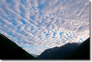
Weather Topic: What are Altocumulus Clouds?
Home - Education - Cloud Types - Altocumulus Clouds
 Next Topic: Altostratus Clouds
Similar to cirrocumulus clouds, altocumulus clouds are
characterized by cloud patches. They are distinguished by larger cloudlets
than cirrocumulus clouds but are still smaller than stratocumulus clouds.
Altocumulus clouds most commonly form in middle altitudes (between 2 and 5 km)
and may resemble, at times, the shape of a flying saucer.
These uncommon formations, called altocumulus lenticularis, are created by uplift
in the atmosphere and are most often seen in close proximity to mountains.
Next Topic: Altostratus Clouds
Current conditions powered by WeatherAPI.com


