Weather Alert in Washington
Hydrologic Outlook issued March 13 at 4:18PM PDT by NWS Pendleton OR
AREAS AFFECTED: Simcoe Highlands; Upper Slopes of the Eastern Washington Cascades Crest; Lower Slopes of the Eastern Washington Cascades Crest
DESCRIPTION: ESFPDT Heavy rain tonight and snowmelt this weekend and early next week will lead to high water levels on streams and rivers along the east slopes of the Washington Cascades and Simcoe Highlands. The Klickitat River near Pitt and the Naches River at Naches are forecast to approach or just barely surpass Action Stage Saturday morning then start receding Saturday afternoon. Other streams and rivers will have rises but remain within their banks. There is some uncertainty in the rain and snow amounts through Saturday and temperatures into early next week but confidence in river levels is good (60-80%). Additionally, water temperatures have dropped to the lower 40s, so the chances of hypothermia will be increased for anyone falling into rivers or streams.
INSTRUCTION: N/A
Want more detail? Get the Complete 7 Day and Night Detailed Forecast!
Current U.S. National Radar--Current
The Current National Weather Radar is shown below with a UTC Time (subtract 5 hours from UTC to get Eastern Time).

National Weather Forecast--Current
The Current National Weather Forecast and National Weather Map are shown below.

National Weather Forecast for Tomorrow
Tomorrow National Weather Forecast and Tomorrow National Weather Map are show below.

North America Water Vapor (Moisture)
This map shows recent moisture content over North America. Bright and colored areas show high moisture (ie, clouds); brown indicates very little moisture present; black indicates no moisture.

Weather Topic: What are Fractus Clouds?
Home - Education - Cloud Types - Fractus Clouds
 Next Topic: Freezing Rain
A fractus cloud (scud) is a fragmented, tattered cloud which has
likely been sheared off of another cloud. They are accessory clouds, meaning they
develop from parent clouds, and are named in a way which describes the original
cloud which contained them.
Fractus clouds which have originated from cumulus clouds are referred to as
cumulus fractus, while fractus clouds which have originated from stratus clouds
are referred to as stratus fractus. Under certain conditions a fractus cloud might
merge with another cloud, or develop into a cumulus cloud, but usually a
fractus cloud seen by itself will dissipate rapidly.
They are often observed on the leading and trailing edges of storm clouds,
and are a display of wind activity.
Next Topic: Freezing Rain
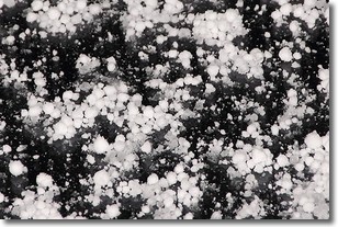
Weather Topic: What is Graupel?
Home - Education - Precipitation - Graupel
 Next Topic: Hail
Graupel is a form of precipitation that is created by atmospheric conditions
which cause supercooled water droplets to contact snow crystals and freeze to
their surface.
Sometimes known as soft hail or snow pellets, graupel is delicate and easily
destroyed by touch. Whereas hail usually falls during severe weather, graupel
doesn't require such conditions to form, and can form in mild precipitation
similar to situations which produce snowfall.
Next Topic: Hail
Current conditions powered by WeatherAPI.com


