Weather Alert in Hawaii
Winter Storm Warning issued March 14 at 3:11PM HST until March 16 at 6:00AM HST by NWS Honolulu HI
AREAS AFFECTED: Big Island Summit
DESCRIPTION: ...WINTER WEATHER WARNING REMAINS IN EFFECT UNTIL 6 AM HST MONDAY FOR THE BIG ISLAND SUMMITS ABOVE 12000 FEET... .A powerful kona low located northwest of the state will bring periods of heavy snow, thunderstorms, and strong winds through Monday morning. * WHAT...Blizzard conditions possible. Additional snow accumulation of 12 to 20 inches. Winds could gust over 100 mph. * WHERE...Big Island Summits. * WHEN...Until 6 AM HST Monday. * IMPACTS...Travel could be very difficult to impossible. Blowing snow will significantly reduce visibility at times, with periods of zero visibility.10
INSTRUCTION: A Winter Storm Warning means significant amounts of snow, sleet, and ice are expected or occurring. Strong winds are also possible. This will make travel very hazardous or impossible. Any travel plans to the summits should be postponed until the threat diminishes.
Want more detail? Get the Complete 7 Day and Night Detailed Forecast!
Current U.S. National Radar--Current
The Current National Weather Radar is shown below with a UTC Time (subtract 5 hours from UTC to get Eastern Time).

National Weather Forecast--Current
The Current National Weather Forecast and National Weather Map are shown below.

National Weather Forecast for Tomorrow
Tomorrow National Weather Forecast and Tomorrow National Weather Map are show below.

North America Water Vapor (Moisture)
This map shows recent moisture content over North America. Bright and colored areas show high moisture (ie, clouds); brown indicates very little moisture present; black indicates no moisture.

Weather Topic: What is Snow?
Home - Education - Precipitation - Snow
 Next Topic: Stratocumulus Clouds
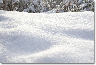
Snow is precipitation taking the form of ice crystals. Each ice crystal, or snowflake,
has unique characteristics, but all of them grow in a hexagonal structure.
Snowfall can last for sustained periods of time and result in significant buildup
of snow on the ground.
On the earth's surface, snow starts out light and powdery, but as it begins to melt
it tends to become more granular, producing small bits of ice which have the consistency of
sand. After several cycles of melting and freezing, snow can become very dense
and ice-like, commonly known as snow pack.
Next Topic: Stratocumulus Clouds
Weather Topic: What are Stratus Clouds?
Home - Education - Cloud Types - Stratus Clouds
 Next Topic: Wall Clouds
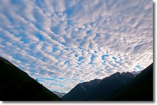
Stratus clouds are similar to altostratus clouds, but form at a
lower altitude and are identified by their fog-like appearance, lacking the
distinguishing features of most clouds.
Stratus clouds are wider than most clouds, and their base has a smooth, uniform
look which is lighter in color than a nimbostratus cloud.
The presence of a stratus cloud indicates the possibility of minor precipitation,
such as drizzle, but heavier precipitation does not typically arrive in the form
of a stratus cloud.
Next Topic: Wall Clouds
Current conditions powered by WeatherAPI.com


