Weather Alert in Alaska
Winter Storm Warning issued March 14 at 2:38PM AKDT until March 16 at 1:00PM AKDT by NWS Juneau AK
AREAS AFFECTED: Petersburg Borough
DESCRIPTION: ...MODERATE TO HEAVY SNOWFALL RETURNS SUNDAY INTO MONDAY... .Bands of snow showers are currently pushing into the NE Gulf as of Saturday afternoon with widely varying conditions. Advisory level snowfall rates of around 1 inch per 3 hours is expected from Yakutat to Sitka, with lighter rates inland. If snow showers train over one location for an extended period of time, visibility could drop to a half mile at times with greater accumulations. This wave of showers is separate from a stronger low pressure system that is expected to track northward across the panhandle starting Sunday morning and continuing through Monday. Steady snowfall will return with heaviest rates across the northern and central Alaska Panhandle starting Sunday morning and continuing into Monday. Current forecast snowfall accumulations within the Winter Storm Warnings are between 6 to 14 inches, with locally higher amounts expected through Monday evening. For southern panhandle communities in Winter Weather Advisories, expecting snowfall accumulations of 3 to 6 inches, highest totals within interior Prince of Wales Island. The main forecast challenge for the southern panhandle will be the timing and transition period to a rain and snow mix, or potentially all rain by Sunday afternoon with temperatures reaching into the upper 30s to low 40s along the coast as the front pushes northward, limiting potential snowfall accumulations. Snow showers will then continue behind this system with widely variable accumulations through the rest of the week. * WHAT...Heavy snow expected. Total snow accumulations of 7 to 12 inches. Winds gusting as high as 45 mph. * WHERE...Petersburg Borough. * WHEN...From 7 AM Sunday to 1 PM AKDT Monday. * IMPACTS...Plan on slippery conditions. * ADDITIONAL DETAILS...Current forecast has heaviest snowfall rates arriving Sunday afternoon into early Monday morning.
INSTRUCTION: If you must travel, keep an extra flashlight, food, and water with you in case of an emergency. People are urged to prepare their property before the onset of winter weather. For the latest road conditions, where available, call 5 1 1 or visit 511.alaska.gov.
Want more detail? Get the Complete 7 Day and Night Detailed Forecast!
Current U.S. National Radar--Current
The Current National Weather Radar is shown below with a UTC Time (subtract 5 hours from UTC to get Eastern Time).

National Weather Forecast--Current
The Current National Weather Forecast and National Weather Map are shown below.

National Weather Forecast for Tomorrow
Tomorrow National Weather Forecast and Tomorrow National Weather Map are show below.

North America Water Vapor (Moisture)
This map shows recent moisture content over North America. Bright and colored areas show high moisture (ie, clouds); brown indicates very little moisture present; black indicates no moisture.

Weather Topic: What is Hail?
Home - Education - Precipitation - Hail
 Next Topic: Hole Punch Clouds
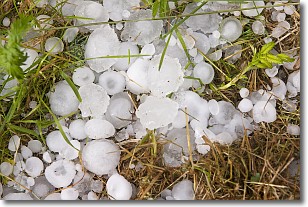
Hail is a form of precipitation which is recognized by large solid balls or
clumps of ice. Hail is created by thunderstorm clouds with strong updrafts of wind.
As the hailstones remain in the updraft, ice is deposited onto them until their
weight becomes heavy enough for them to fall to the earth's surface.
Hail storms can cause significant damage to crops, aircrafts, and man-made structures,
despite the fact that the duration is usually less than ten minutes.
Next Topic: Hole Punch Clouds
Weather Topic: What are Mammatus Clouds?
Home - Education - Cloud Types - Mammatus Clouds
 Next Topic: Nimbostratus Clouds
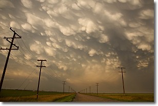
A mammatus cloud is a cloud with a unique feature which resembles
a web of pouches hanging along the base of the cloud.
In the United States, mammatus clouds tend to form in the warmer months, commonly
in the Midwest and eastern regions.
While they usually form at the bottom of a cumulonimbis cloud, they can also form
under altostratus, altocumulus, stratocumulus, and cirrus clouds. Mammatus clouds
warn that severe weather is close.
Next Topic: Nimbostratus Clouds
Current conditions powered by WeatherAPI.com


