Weather Alert in Alaska
Winter Storm Warning issued March 14 at 2:38PM AKDT until March 16 at 1:00PM AKDT by NWS Juneau AK
AREAS AFFECTED: Glacier Bay; Eastern Chichagof Island; City and Borough of Juneau
DESCRIPTION: ...MODERATE TO HEAVY SNOWFALL RETURNS SUNDAY INTO MONDAY... .Bands of snow showers are currently pushing into the NE Gulf as of Saturday afternoon with widely varying conditions. Advisory level snowfall rates of around 1 inch per 3 hours is expected from Yakutat to Sitka, with lighter rates inland. If snow showers train over one location for an extended period of time, visibility could drop to a half mile at times with greater accumulations. This wave of showers is separate from a stronger low pressure system that is expected to track northward across the panhandle starting Sunday morning and continuing through Monday. Steady snowfall will return with heaviest rates across the northern and central Alaska Panhandle starting Sunday morning and continuing into Monday. Current forecast snowfall accumulations within the Winter Storm Warnings are between 6 to 14 inches, with locally higher amounts expected through Monday evening. For southern panhandle communities in Winter Weather Advisories, expecting snowfall accumulations of 3 to 6 inches, highest totals within interior Prince of Wales Island. The main forecast challenge for the southern panhandle will be the timing and transition period to a rain and snow mix, or potentially all rain by Sunday afternoon with temperatures reaching into the upper 30s to low 40s along the coast as the front pushes northward, limiting potential snowfall accumulations. Snow showers will then continue behind this system with widely variable accumulations through the rest of the week. * WHAT...Heavy snow expected. Total snow accumulations of 8 to 14 inches. Winds gusting as high as 35 mph. * WHERE...Glacier Bay, Eastern Chichagof Island and City and Borough of Juneau. Reduced visibilities of 1 mile or less. * WHEN...From 1 PM Sunday to 1 PM AKDT Monday. * IMPACTS...Travel will be very difficult and is discouraged. The hazardous conditions could impact the Sunday evening or Monday morning. * ADDITIONAL DETAILS...Current forecast has heaviest snowfall rates arriving Sunday evening into early Monday morning across the Icy Strait corridor communities, including Juneau.
INSTRUCTION: If you must travel, keep an extra flashlight, food, and water with you in case of an emergency. People are urged to prepare their property before the onset of winter weather. For the latest road conditions, where available, call 5 1 1 or visit 511.alaska.gov. Mariners should prepare their vessels for heavy snow.
Want more detail? Get the Complete 7 Day and Night Detailed Forecast!
Current U.S. National Radar--Current
The Current National Weather Radar is shown below with a UTC Time (subtract 5 hours from UTC to get Eastern Time).

National Weather Forecast--Current
The Current National Weather Forecast and National Weather Map are shown below.

National Weather Forecast for Tomorrow
Tomorrow National Weather Forecast and Tomorrow National Weather Map are show below.

North America Water Vapor (Moisture)
This map shows recent moisture content over North America. Bright and colored areas show high moisture (ie, clouds); brown indicates very little moisture present; black indicates no moisture.

Weather Topic: What are Altostratus Clouds?
Home - Education - Cloud Types - Altostratus Clouds
 Next Topic: Cirrocumulus Clouds
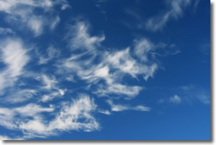
Altostratus clouds form at mid to high-level altitudes
(between 2 and 7 km) and are created by a warm, stable air mass which causes
water vapor
to condense as it rise through the atmosphere. Usually altostratus clouds are
featureless sheets characterized by a uniform color.
In some cases, wind punching through the cloud formation may give it a waved
appearance, called altostratus undulatus. Altostratus clouds
are commonly seen with other cloud formations accompanying them.
Next Topic: Cirrocumulus Clouds
Weather Topic: What are Cirrostratus Clouds?
Home - Education - Cloud Types - Cirrostratus Clouds
 Next Topic: Cirrus Clouds
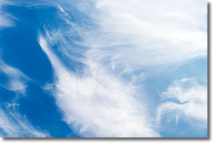
Cirrostratus clouds are high, thin clouds that form above
20,000 feet and are made mostly of ice crystals. They sometimes look like giant
feathers, horse tails, or curls of hair in the sky.
These clouds are pushed by the jet stream and can move at high speeds reaching
100 mph.
What do they indicate?
They indicate that a precipitation is likely within 24 hours.
Next Topic: Cirrus Clouds
Current conditions powered by WeatherAPI.com


