Weather Alert in Alaska
Winter Weather Advisory issued March 14 at 2:38PM AKDT until March 15 at 7:00PM AKDT by NWS Juneau AK
AREAS AFFECTED: Ketchikan Gateway Borough; Annette Island
DESCRIPTION: ...MODERATE TO HEAVY SNOWFALL RETURNS SUNDAY INTO MONDAY... .Bands of snow showers are currently pushing into the NE Gulf as of Saturday afternoon with widely varying conditions. Advisory level snowfall rates of around 1 inch per 3 hours is expected from Yakutat to Sitka, with lighter rates inland. If snow showers train over one location for an extended period of time, visibility could drop to a half mile at times with greater accumulations. This wave of showers is separate from a stronger low pressure system that is expected to track northward across the panhandle starting Sunday morning and continuing through Monday. Steady snowfall will return with heaviest rates across the northern and central Alaska Panhandle starting Sunday morning and continuing into Monday. Current forecast snowfall accumulations within the Winter Storm Warnings are between 6 to 14 inches, with locally higher amounts expected through Monday evening. For southern panhandle communities in Winter Weather Advisories, expecting snowfall accumulations of 3 to 6 inches, highest totals within interior Prince of Wales Island. The main forecast challenge for the southern panhandle will be the timing and transition period to a rain and snow mix, or potentially all rain by Sunday afternoon with temperatures reaching into the upper 30s to low 40s along the coast as the front pushes northward, limiting potential snowfall accumulations. Snow showers will then continue behind this system with widely variable accumulations through the rest of the week. * WHAT...Snow expected. Total snow accumulations of 4 to 6 inches. Winds gusting as high as 50 to 60 mph. * WHERE...Ketchikan Gateway Borough and Annette Island. * WHEN...From 4 AM to 7 PM AKDT Sunday. * IMPACTS...Travel could be very difficult. Strong winds can create times of blowing snow with reduced visibility. * ADDITIONAL DETAILS...A strong front will push into the southern panhandle starting late Sunday morning, initially bringing widespread snowfall across the area. As this front pushes northward, temperatures across the southern panhandle will warm with an expected changeover to a rain/snow mix or all rain by Sunday evening. Main forecast challenge will be the timing of this change over and the resulting snowfall accumulations.
INSTRUCTION: Slow down and use caution while traveling. People are urged to prepare their property before the onset of winter weather. For the latest road conditions, where available, call 5 1 1 or visit 511.alaska.gov. Mariners should prepare their vessels for heavy snow followed by heavy rain. Check bilge pumps.
Want more detail? Get the Complete 7 Day and Night Detailed Forecast!
Current U.S. National Radar--Current
The Current National Weather Radar is shown below with a UTC Time (subtract 5 hours from UTC to get Eastern Time).

National Weather Forecast--Current
The Current National Weather Forecast and National Weather Map are shown below.

National Weather Forecast for Tomorrow
Tomorrow National Weather Forecast and Tomorrow National Weather Map are show below.

North America Water Vapor (Moisture)
This map shows recent moisture content over North America. Bright and colored areas show high moisture (ie, clouds); brown indicates very little moisture present; black indicates no moisture.

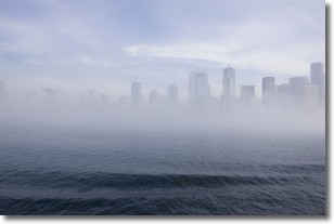
Weather Topic: What is Fog?
Home - Education - Cloud Types - Fog
 Next Topic: Fractus Clouds
Fog is technically a type of stratus cloud, which lies along the
ground and obscures visibility.
It is usually created when humidity in the air condenses into tiny water droplets.
Because of this, some places are more prone to foggy weather, such as regions
close to a body of water.
Fog is similar to mist; both are the appearance of water droplets suspended in
the air, but fog is the term applied to the condition when visibility is less than 1 km.
Next Topic: Fractus Clouds
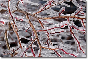
Weather Topic: What is Freezing Rain?
Home - Education - Precipitation - Freezing Rain
 Next Topic: Graupel
Freezing rain is a condition where precipitation which has fallen in the form of
water droplets reaches temperatures which are below freezing and freezes upon
coming into contact
with surface objects. The result of this precipitation is a glaze of ice which
can be damaging to plants and man-made structures. A severe onset of freezing
rain which results in a very thick glaze of ice is known as an ice storm.
Next Topic: Graupel
Current conditions powered by WeatherAPI.com


