Weather Alert in Minnesota
Flood Warning issued June 13 at 9:14AM CDT until June 14 at 9:15AM CDT by NWS Aberdeen SD
AREAS AFFECTED: Big Stone, MN; Roberts, SD
DESCRIPTION: * WHAT...Flooding caused by excessive rainfall is occurring. * WHERE...Portions of west central Minnesota, including the following county, Big Stone and northeast South Dakota, including the following county, Roberts. * WHEN...Until 915 AM CDT Saturday. * IMPACTS...Flooding of rivers, creeks, streams, and other low-lying and flood-prone locations is imminent or occurring. Numerous roads remain closed due to flooding. Expect many areas of slow moving or standing water. * ADDITIONAL DETAILS... - At 905 AM CDT, Emergency Management reported flooding in the warned area. Flooding is already occurring. Several streets in Sisseton, as well as many county and township roads across Roberts and Big Stone counties are either closed or affected by standing water. Between 3 and 6 inches of rain have fallen, with locally higher amounts in excess of 7 inches. - Flooding impacts will continue, but no additional rainfall is expected. - Some locations that will experience flooding include... Sisseton, Agency Village, Browns Valley, Wilmot, Clinton, Peever, Peever Flats Housing, Yankeetown, Bonanza Grove, Dakota Connection & Casino, Finley Heights Housing, Big Stone Lake, Lake Traverse, Lismore Colony, Lagoona Beach and Lake Traverse Reservation. - http://www.weather.gov/safety/flood
INSTRUCTION: Turn around, don't drown when encountering flooded roads. Most flood deaths occur in vehicles. Please report observed flooding to local emergency services or law enforcement and request they pass this information to the National Weather Service when you can do so safely.
Want more detail? Get the Complete 7 Day and Night Detailed Forecast!
Current U.S. National Radar--Current
The Current National Weather Radar is shown below with a UTC Time (subtract 5 hours from UTC to get Eastern Time).

National Weather Forecast--Current
The Current National Weather Forecast and National Weather Map are shown below.

National Weather Forecast for Tomorrow
Tomorrow National Weather Forecast and Tomorrow National Weather Map are show below.

North America Water Vapor (Moisture)
This map shows recent moisture content over North America. Bright and colored areas show high moisture (ie, clouds); brown indicates very little moisture present; black indicates no moisture.

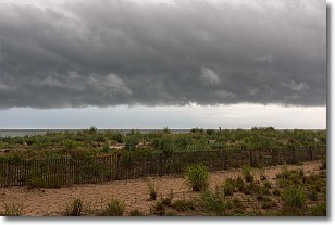
Weather Topic: What are Shelf Clouds?
Home - Education - Cloud Types - Shelf Clouds
 Next Topic: Sleet
A shelf cloud is similar to a wall cloud, but forms at the front
of a storm cloud, instead of at the rear, where wall clouds form.
A shelf cloud is caused by a series of events set into motion by the advancing
storm; first, cool air settles along the ground where precipitation has just fallen.
As the cool air is brought in, the warmer air is displaced, and rises above it,
because it is less dense. When the warmer air reaches the bottom of the storm cloud,
it begins to cool again, and the resulting condensation is a visible shelf cloud.
Next Topic: Sleet
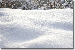
Weather Topic: What is Snow?
Home - Education - Precipitation - Snow
 Next Topic: Stratocumulus Clouds
Snow is precipitation taking the form of ice crystals. Each ice crystal, or snowflake,
has unique characteristics, but all of them grow in a hexagonal structure.
Snowfall can last for sustained periods of time and result in significant buildup
of snow on the ground.
On the earth's surface, snow starts out light and powdery, but as it begins to melt
it tends to become more granular, producing small bits of ice which have the consistency of
sand. After several cycles of melting and freezing, snow can become very dense
and ice-like, commonly known as snow pack.
Next Topic: Stratocumulus Clouds
Current conditions powered by WeatherAPI.com


