Weather Alert in West Virginia
Snow Squall Warning issued March 17 at 11:49AM EDT until March 17 at 12:15PM EDT by NWS Charleston WV
AREAS AFFECTED: Kanawha, WV; Lincoln, WV; Putnam, WV
DESCRIPTION: The National Weather Service in Charleston West Virginia has issued a * Snow Squall Warning for... East central Putnam County in western West Virginia... Central Kanawha County in central West Virginia... Northeastern Lincoln County in central West Virginia... * Until 1215 PM EDT. * At 1148 AM EDT, a dangerous snow squall was located over Institute, or near Nitro, moving east at 20 mph. HAZARD...Whiteout conditions with near zero visibility associated with intense bursts of heavy snow and gusty winds leading to blowing snow. Wind gusts up to 35 mph. SOURCE...Radar indicated. IMPACT...Travel will become difficult and potentially dangerous within minutes. This includes the following highways... Interstate 79 between mile markers 1 and 11. Interstate 77 in West Virginia between mile markers 96 and 113. Interstate 64 in West Virginia between mile markers 43 and 57. West Virginia Turnpike between mile markers 93 and 95. Route 119 between mile markers 71 and 80. Locations impacted include... Charleston, Nitro, Jefferson, South Charleston, St. Albans, Dunbar, Sissonville, Poca, Cross Lanes, Pinch, Institute, Tornado, Coal Fork, Elkview, Alum Creek, and Teays Valley.
INSTRUCTION: Slow Down! Rapid changes in visibility and road conditions are expected with this dangerous snow squall. Be alert for sudden whiteout conditions.
Want more detail? Get the Complete 7 Day and Night Detailed Forecast!
Current U.S. National Radar--Current
The Current National Weather Radar is shown below with a UTC Time (subtract 5 hours from UTC to get Eastern Time).

National Weather Forecast--Current
The Current National Weather Forecast and National Weather Map are shown below.

National Weather Forecast for Tomorrow
Tomorrow National Weather Forecast and Tomorrow National Weather Map are show below.

North America Water Vapor (Moisture)
This map shows recent moisture content over North America. Bright and colored areas show high moisture (ie, clouds); brown indicates very little moisture present; black indicates no moisture.

Weather Topic: What are Contrails?
Home - Education - Cloud Types - Contrails
 Next Topic: Cumulonimbus Clouds
A contrail is an artificial cloud, created by the passing of an
aircraft.
Contrails form because water vapor in the exhaust of aircraft engines is suspended
in the air under certain temperatures and humidity conditions. These contrails
are called exhaust contrails.
Another type of contrail can form due to a temporary reduction in air pressure
moving over the plane's surface, causing condensation.
These are called aerodynamic contrails.
When you can see your breath on a cold day, it is also because of condensation.
The reason contrails last longer than the condensation from your breath is
because the water in contrails freezes into ice particles.
Next Topic: Cumulonimbus Clouds
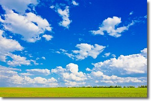
Weather Topic: What are Cumulus Clouds?
Home - Education - Cloud Types - Cumulus Clouds
 Next Topic: Drizzle
Cumulus clouds are fluffy and textured with rounded tops, and
may have flat bottoms. The border of a cumulus cloud
is clearly defined, and can have the appearance of cotton or cauliflower.
Cumulus clouds form at low altitudes (rarely above 2 km) but can grow very tall,
becoming cumulus congestus and possibly the even taller cumulonimbus clouds.
When cumulus clouds become taller, they have a greater chance of producing precipitation.
Next Topic: Drizzle
Current conditions powered by WeatherAPI.com


