Weather Alerts for Arizona
1. Extreme Heat Watch for: Cave Creek/New River; Fountain Hills/East Mesa; Apache Junction/Gold Canyon
2. Extreme Heat Watch for: Kofa; Yuma; Central La Paz; Aguila Valley; Southeast Yuma County; Gila River Valley; Tonopah Desert; Gila Bend; Northwest Pinal County; West Pinal County; Sonoran Desert Natl Monument
3. Extreme Heat Watch for: Northwest Valley; Buckeye/Avondale; Deer Valley; Central Phoenix; North Phoenix/Glendale; Scottsdale/Paradise Valley; East Valley; South Mountain/Ahwatukee; Southeast Valley/Queen Creek
4. Extreme Heat Watch for: Parker Valley; Joshua Tree NP East; Imperial County Southwest; Salton Sea; Chuckwalla Mountains; Imperial County Southeast; Imperial County West; Imperial Valley; Chiriaco Summit; Palo Verde Valley; Chuckwalla Valley
5. Extreme Heat Watch for: Upper Santa Cruz River and Altar Valleys including Nogales; Upper San Pedro River Valley including Sierra Vista/Benson; Eastern Cochise County Below 5000 Feet including Douglas/Willcox; Upper Gila River and Aravaipa Valleys including Clifton/Safford
6. Extreme Heat Watch for: Western Pima County Including Ajo/Organ Pipe Cactus National Monument; Tohono O'odham Nation including Sells; Tucson Metro Area including Tucson/Green Valley/Marana/Vail; South Central Pinal County including Eloy/Picacho Peak State Park; Southeast Pinal County including Kearny/Mammoth/Oracle
7. Lake Wind Advisory for: Lake Havasu and Fort Mohave; Lake Mead National Recreation Area; San Bernardino County-Upper Colorado River Valley; Lake Mead National Recreation Area
Want more detail? Get the Complete 7 Day and Night Detailed Forecast!
Current U.S. National Radar--Current
The Current National Weather Radar is shown below with a UTC Time (subtract 5 hours from UTC to get Eastern Time).

National Weather Forecast--Current
The Current National Weather Forecast and National Weather Map are shown below.

National Weather Forecast for Tomorrow
Tomorrow National Weather Forecast and Tomorrow National Weather Map are show below.

North America Water Vapor (Moisture)
This map shows recent moisture content over North America. Bright and colored areas show high moisture (ie, clouds); brown indicates very little moisture present; black indicates no moisture.

Weather Topic: What are Altostratus Clouds?
Home - Education - Cloud Types - Altostratus Clouds
 Next Topic: Cirrocumulus Clouds
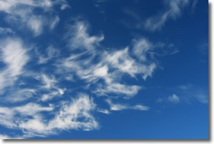
Altostratus clouds form at mid to high-level altitudes
(between 2 and 7 km) and are created by a warm, stable air mass which causes
water vapor
to condense as it rise through the atmosphere. Usually altostratus clouds are
featureless sheets characterized by a uniform color.
In some cases, wind punching through the cloud formation may give it a waved
appearance, called altostratus undulatus. Altostratus clouds
are commonly seen with other cloud formations accompanying them.
Next Topic: Cirrocumulus Clouds
Weather Topic: What are Cirrostratus Clouds?
Home - Education - Cloud Types - Cirrostratus Clouds
 Next Topic: Cirrus Clouds
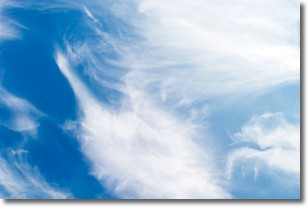
Cirrostratus clouds are high, thin clouds that form above
20,000 feet and are made mostly of ice crystals. They sometimes look like giant
feathers, horse tails, or curls of hair in the sky.
These clouds are pushed by the jet stream and can move at high speeds reaching
100 mph.
What do they indicate?
They indicate that a precipitation is likely within 24 hours.
Next Topic: Cirrus Clouds
Current conditions powered by WeatherAPI.com


