Weather Alerts for Arizona
1. Extreme Heat Watch for: Cave Creek/New River; Fountain Hills/East Mesa; Apache Junction/Gold Canyon
2. Extreme Heat Watch for: Kofa; Yuma; Central La Paz; Aguila Valley; Southeast Yuma County; Gila River Valley; Tonopah Desert; Gila Bend; Northwest Pinal County; West Pinal County; Sonoran Desert Natl Monument
3. Extreme Heat Watch for: Northwest Valley; Buckeye/Avondale; Deer Valley; Central Phoenix; North Phoenix/Glendale; Scottsdale/Paradise Valley; East Valley; South Mountain/Ahwatukee; Southeast Valley/Queen Creek
4. Extreme Heat Watch for: Parker Valley; Joshua Tree NP East; Imperial County Southwest; Salton Sea; Chuckwalla Mountains; Imperial County Southeast; Imperial County West; Imperial Valley; Chiriaco Summit; Palo Verde Valley; Chuckwalla Valley
5. Extreme Heat Watch for: Upper Santa Cruz River and Altar Valleys including Nogales; Upper San Pedro River Valley including Sierra Vista/Benson; Eastern Cochise County Below 5000 Feet including Douglas/Willcox; Upper Gila River and Aravaipa Valleys including Clifton/Safford
6. Extreme Heat Watch for: Western Pima County Including Ajo/Organ Pipe Cactus National Monument; Tohono O'odham Nation including Sells; Tucson Metro Area including Tucson/Green Valley/Marana/Vail; South Central Pinal County including Eloy/Picacho Peak State Park; Southeast Pinal County including Kearny/Mammoth/Oracle
7. Lake Wind Advisory for: Lake Havasu and Fort Mohave; Lake Mead National Recreation Area; San Bernardino County-Upper Colorado River Valley; Lake Mead National Recreation Area
Want more detail? Get the Complete 7 Day and Night Detailed Forecast!
Current U.S. National Radar--Current
The Current National Weather Radar is shown below with a UTC Time (subtract 5 hours from UTC to get Eastern Time).

National Weather Forecast--Current
The Current National Weather Forecast and National Weather Map are shown below.

National Weather Forecast for Tomorrow
Tomorrow National Weather Forecast and Tomorrow National Weather Map are show below.

North America Water Vapor (Moisture)
This map shows recent moisture content over North America. Bright and colored areas show high moisture (ie, clouds); brown indicates very little moisture present; black indicates no moisture.

Weather Topic: What is Rain?
Home - Education - Precipitation - Rain
 Next Topic: Shelf Clouds
Precipitation in the form of water droplets is called rain.
Rain generally has a tendency to fall with less intensity over a greater period
of time, and when rainfall is more severe it is usually less sustained.
Rain is the most common form of precipitation and happens with greater frequency
depending on the season and regional influences. Cities have been shown to have
an observable effect on rainfall, due to an effect called the urban heat island.
Compared to upwind, monthly rainfall between twenty and forty miles downwind of
cities is 30% greater.
Next Topic: Shelf Clouds
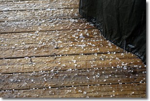
Weather Topic: What is Sleet?
Home - Education - Precipitation - Sleet
 Next Topic: Snow
Sleet is a form of precipitation in which small ice pellets are the primary
components. These ice pellets are smaller and more translucent than hailstones,
and harder than graupel. Sleet is caused by specific atmospheric conditions and
therefore typically doesn't last for extended periods of time.
The condition which leads to sleet formation requires a warmer body of air to be
wedged in between two sub-freezing bodies of air. When snow falls through a warmer
layer of air it melts, and as it falls through the next sub-freezing body of air
it freezes again, forming ice pellets known as sleet. In some cases, water
droplets don't have time to freeze before reaching the surface and the result is
freezing rain.
Next Topic: Snow
Current conditions powered by WeatherAPI.com


