Weather Alerts for California
1. Extreme Heat Watch for: Catalina and Santa Barbara Islands; Santa Clarita Valley; San Luis Obispo County Beaches; San Luis Obispo County Inland Central Coast; Santa Lucia Mountains; Santa Barbara County Central Coast Beaches; Santa Barbara County Inland Central Coast; Santa Ynez Valley; Santa Barbara County Southwestern Coast; Santa Barbara County Southeastern Coast; Santa Ynez Mountains Western Range; Santa Ynez Mountains Eastern Range; Ventura County Beaches; Ventura County Inland Coast; Lake Casitas; Ojai Valley; Central Ventura County Valleys; Los Angeles County Beaches; Palos Verdes Hills; Los Angeles County Inland Coast including Downtown Los Angeles; Western Santa Monica Mountains Recreational Area; Eastern Santa Monica Mountains Recreational Area; Calabasas and Agoura Hills; Western San Fernando Valley; Eastern San Fernando Valley; Southeastern Ventura County Valleys; Santa Susana Mountains; Los Angeles County San Gabriel Valley
2. Extreme Heat Watch for: Malibu Coast; San Miguel and Santa Rosa Islands; Santa Cruz and Anacapa Islands
3. Extreme Heat Watch for: San Luis Obispo County Mountains; Santa Barbara County Interior Mountains; Southern Ventura County Mountains; Interstate 5 Corridor; Western San Gabriel Mountains and Highway 14 Corridor; Eastern San Gabriel Mountains
4. Heat Advisory for: Catalina and Santa Barbara Islands; Santa Clarita Valley; San Luis Obispo County Beaches; San Luis Obispo County Inland Central Coast; Santa Lucia Mountains; Santa Barbara County Central Coast Beaches; Santa Barbara County Inland Central Coast; Santa Ynez Valley; Santa Barbara County Southwestern Coast; Santa Barbara County Southeastern Coast; Santa Ynez Mountains Western Range; Santa Ynez Mountains Eastern Range; Ventura County Beaches; Ventura County Inland Coast; Lake Casitas; Ojai Valley; Central Ventura County Valleys; Los Angeles County Beaches; Palos Verdes Hills; Los Angeles County Inland Coast including Downtown Los Angeles; Western Santa Monica Mountains Recreational Area; Eastern Santa Monica Mountains Recreational Area; Calabasas and Agoura Hills; Western San Fernando Valley; Eastern San Fernando Valley; Southeastern Ventura County Valleys; Santa Susana Mountains; Los Angeles County San Gabriel Valley
5. Heat Advisory for: San Diego County Coastal Areas; San Bernardino and Riverside County Valleys-The Inland Empire; San Diego County Inland Valleys; Santa Ana Mountains and Foothills; Orange County Coastal; Orange County Inland
6. Heat Advisory for: San Francisco; Marin Coastal Range; Sonoma Coastal Range; North Bay Interior Mountains; Coastal North Bay Including Point Reyes National Seashore; North Bay Interior Valleys; San Francisco Bay Shoreline; San Francisco Peninsula Coast; East Bay Interior Valleys; Santa Cruz Mountains; Santa Clara Valley Including San Jose; Eastern Santa Clara Hills; East Bay Hills; Southern Salinas Valley/Arroyo Seco and Lake San Antonio; Santa Lucia Mountains and Los Padres National Forest; Mountains Of San Benito County And Interior Monterey County Including Pinnacles National Park; Northern Salinas Valley/Hollister Valley and Carmel Valley; Northern Monterey Bay; Southern Monterey Bay and Big Sur Coast
7. Heat Advisory for: San Luis Obispo County Mountains; Santa Barbara County Interior Mountains; Southern Ventura County Mountains; Interstate 5 Corridor; Western San Gabriel Mountains and Highway 14 Corridor; Eastern San Gabriel Mountains
8. Wind Advisory for: Mojave Desert Slopes
Want more detail? Get the Complete 7 Day and Night Detailed Forecast!
Current U.S. National Radar--Current
The Current National Weather Radar is shown below with a UTC Time (subtract 5 hours from UTC to get Eastern Time).

National Weather Forecast--Current
The Current National Weather Forecast and National Weather Map are shown below.

National Weather Forecast for Tomorrow
Tomorrow National Weather Forecast and Tomorrow National Weather Map are show below.

North America Water Vapor (Moisture)
This map shows recent moisture content over North America. Bright and colored areas show high moisture (ie, clouds); brown indicates very little moisture present; black indicates no moisture.

Weather Topic: What is Drizzle?
Home - Education - Precipitation - Drizzle
 Next Topic: Evaporation
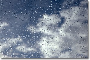
Drizzle is precipitation in the form of water droplets which are
smaller than raindrops.
Drizzle is characterized by fine, gently falling droplets and typically does not
impact human habitation in a negative way. The exception to this is freezing drizzle,
a condition where drizzle freezes immediately upon reaching earth's surface.
Freezing drizzle is still less dangerous than freezing rain, but can
potentially result in hazardous road conditions.
Next Topic: Evaporation
Weather Topic: What is Fog?
Home - Education - Cloud Types - Fog
 Next Topic: Fractus Clouds
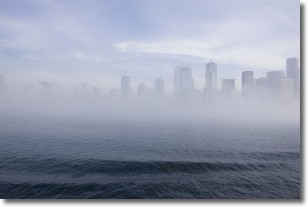
Fog is technically a type of stratus cloud, which lies along the
ground and obscures visibility.
It is usually created when humidity in the air condenses into tiny water droplets.
Because of this, some places are more prone to foggy weather, such as regions
close to a body of water.
Fog is similar to mist; both are the appearance of water droplets suspended in
the air, but fog is the term applied to the condition when visibility is less than 1 km.
Next Topic: Fractus Clouds
Current conditions powered by WeatherAPI.com


